
Trails / Tennessee / Cumberland Plateau
Virgin Falls Trail
Scott's Gulf Wilderness State Park (Virgin Falls State Natural Area)
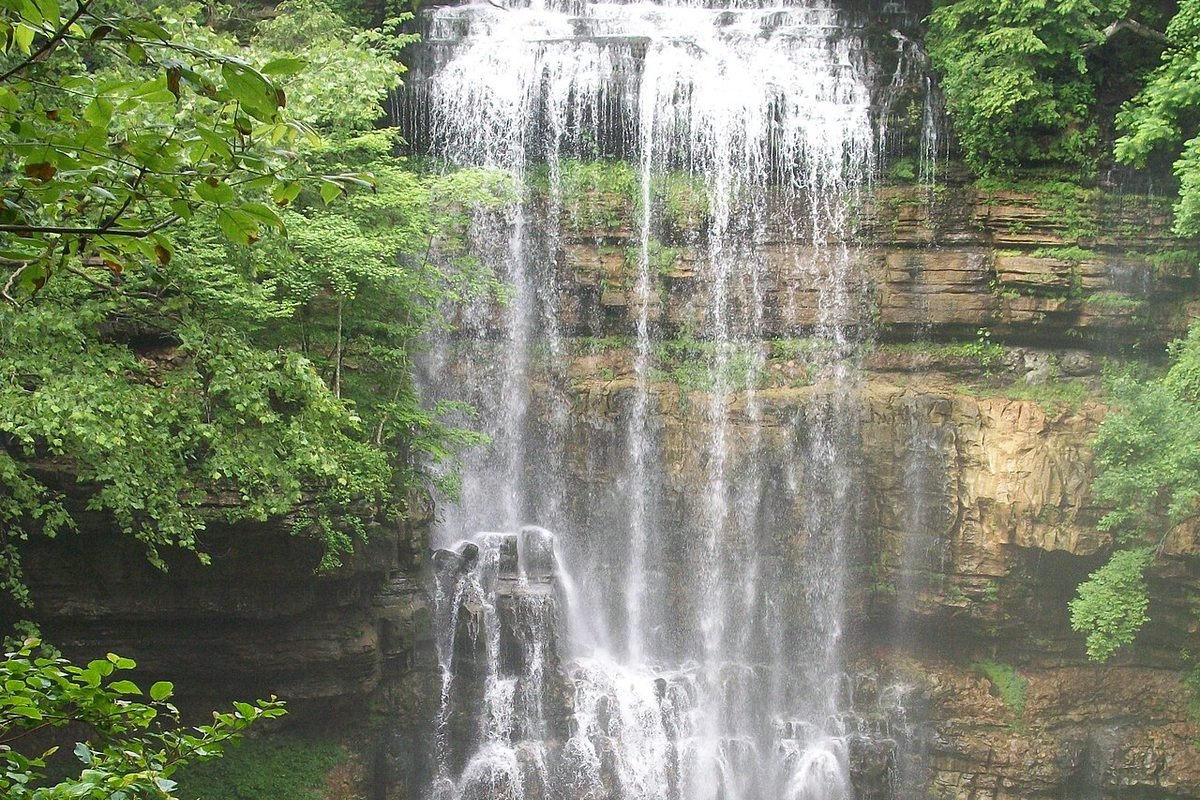
Virgin Falls is one of Tennessee’s genuinely odd places. A creek comes out of a cave mouth high on a cliff, drops 110 feet, and vanishes into another cave at the bottom. It never becomes a river above ground. Getting there is a real day out, and the hike is honest about it: the trip in is a long, mostly downhill walk, and the trip out is the price you pay.
The hike
The trailhead lot on Scotts Gulf Road is small and can fill up, so arrive early. The trail leaves through upland oak and hickory forest with a gentle descent into the Big Branch drainage, and Big Branch Falls comes before Big Laurel Falls. Flow varies with the weather: one reviewer found it completely dry, while another says all the falls were flowing well. As the trail drops into the gorge, the forest shifts to hemlock and mixed hardwoods, and small rockhouses, boulder fields, and sinkholes come one after another.
The best-known side trip is Martha’s Pretty Point. The park says the Upland Trail branches off the main trail about 0.2 miles from the trailhead, follows an old road through a loblolly pine plantation, and crosses Big Laurel Creek at about 0.9 miles, which can be hard to cross at high water. At 2.18 miles you reach the campsites and the overlook, with a view of Scott’s Gulf and the Caney Fork River 900 feet below. It says you can return on the main Virgin Falls Trail to make a 5-mile loop, and one hiker says adding the overlook stretched their day by about 1.5 miles.
Back on the main trail, Big Laurel Falls drops along Big Laurel Creek, and one reference says a substantial limestone cave lies behind it. A junction with the Hemlock Springs Trail comes close by. About 0.8 miles later, one hiking site says, the Sheep Cave Trail heads off to the right. The park puts a junction at 3.6 miles where bearing right leads to Sheep’s Cave and its waterfall, which drops into a large sink. The same reference lists Sheep Falls at 90 feet. The natural area’s official page says there is a cable crossing at Big Laurel Creek at 1.5 miles and warns not to attempt it if the creek is flooding. The trail continues past a junction with the Caney Fork River Trail, which one hiking site calls a nice walk down to the river.
Virgin Falls itself is the reward. The creek emerges from a cave, plunges 110 feet, and disappears into another cave at the base, and one route-planning site says you can walk behind it. The park calls the hike in 4.3 miles and strenuous, and adds that the way back out is tough. The most challenging sections, one reviewer says, come on the loop down to and around the falls. The natural area’s page calls the hike strenuous, around 9 miles in and out, with a descent of about 900 feet that you climb back on the way out, and says to allow 5 to 9 hours.
If a long day isn’t the goal, the park says Lost Creek Falls is easier to see and very beautiful. One reference describes it as a 60-foot waterfall with a large cave system in the Lost Creek State Natural Area. The state lists other waterfalls here too, including Rylander Cascades and the double-drop Dry Creek Falls.
Caves in the area are closed to visitors because of white-nose syndrome, a fungal disease that kills bats, so admire the cave mouths from the trail.
Tips
- Plan a full day. The state park estimates five to eight hours round trip, depending on pace and side trips. Start early enough that the return doesn’t run into dark.
- Carry a headlamp anyway, plus more water than feels necessary and sturdy shoes with good tread.
- Poles help on the climb out.
- Watch the water. There are creek crossings, including one near the Cable Crossing camping area. Don’t attempt them in high water after heavy rain.
- Be honest about your fitness. Sources describe the hike as strenuous, and it takes a certain level of conditioning.
Camping
Virgin Falls is popular with backpackers, and camping here is well organized. Sites are in four designated areas: Martha’s Pretty Point, Cable Crossing, Caney Fork, and Virgin Falls itself. Backcountry camping is allowed at designated sites only, and backpackers are required to reserve through the state parks’ online system. Parking for backcountry camping is at the same trailhead on Scotts Gulf Road. The natural area’s page adds that no camping is allowed above Virgin Falls.
All sites are primitive. There is no water or electricity, so you carry water in or filter it from a natural source, and at some sites the nearest natural water can run dry in summer and fall, so check your site’s description when you reserve.
Inside Intel: Campers most often point first-timers to Martha’s Pretty Point. It’s a camper favorite for its overlook, which one reviewer called out for its sunset, and the sites there are spaced out more generously than at some other areas. One camper’s advice on the individual sites: numbers 4 through 7 sit up on the point, with 7 the largest and most secluded and 6 also very nice. Skip 4, which sits right at the overlook, because day hikers walk through it, and 5 runs along the main trail. The catch is water, since there’s none at the point and the nearest source can be a trickle in dry months. If you’d rather sleep to the sound of moving water, Caney Fork is the option near the river. The camp at Virgin Falls is the closest to the waterfall but sits on a slope with limited flat ground.
Trail facts
- Distance: About 8 to 9 miles round trip (4 miles one way per the natural area’s page; some guides say 4.3).
- Route type: Out and back
- Difficulty: Strenuous
- Elevation: Descends roughly 900 to 1,000 feet to the falls. All of it is regained on the return.
- Time: 5 to 8 hours as a day hike
- Best season: Not verified. Check water levels after heavy rain.
- Trailhead: 2080 Scotts Gulf Road, Sparta, TN
- Camping: Designated backcountry sites only, in four areas (Martha’s Pretty Point, Cable Crossing, Caney Fork, Virgin Falls). Online reservation required. All primitive: no water, no electricity. Dispersed camping is not allowed.
- Water: Carry it in or filter it from a natural source. At some sites the nearest source can run dry in summer and fall.
- Permits: Reservation required through the state park system (online).
- Dogs: Allowed on leash, per the natural area’s page
- Last verified: October 17, 2026
Have a great pic of this trail? Post it to Instagram and tag us, and we might use it on the site.
More Lowdown from Backpack Trail Guide
Where this comes from
This page draws on the sources below, along with other guides and trip reports. Links go to the original pages.
- Tennessee Department of Environment and Conservation: Virgin Falls State Natural Area
- Tennessee Department of Environment and Conservation: Virgin Falls (site page)
- Wikipedia: Scott’s Gulf
- TennGreen Land Conservancy: Virgin Falls
Before you go: This page is based on published trail guides, trip reports, and reviews, along with official park and agency information where we could find it. It’s meant to help backpackers discover new trails, not to replace current, official information. Conditions, closures, permits, campsites, and water sources change, and some details here may be out of date or wrong. Confirm everything with the managing agency and check current conditions before you head out, and don’t rely on this page alone for safety or navigation. Backcountry travel involves risk.