
Trails / Tennessee / Cherokee National Forest and AT
Big Frog Wilderness Loop
Big Frog Wilderness, Cherokee National Forest (Polk County, near the Georgia line)
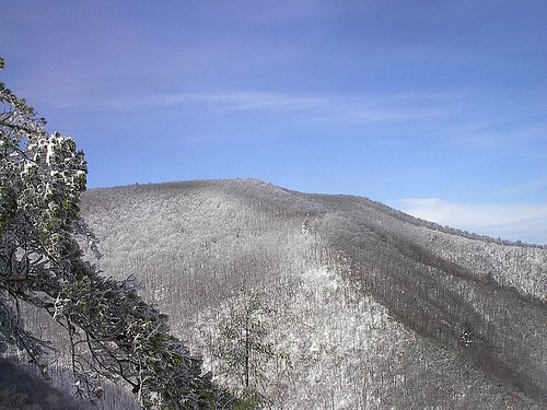
Big Frog Mountain is the high point of a wilderness the forest describes as known for solitude and backcountry adventure. At 4,224 feet, it’s one of the first big peaks east of Oklahoma, and the loop over it runs through rhododendron tunnels, open ridges with valley views, and forest camps on the summit.
The hike
Big Frog Mountain is the high point of the combined Cohutta and Big Frog wilderness, which one climbing site describes as 45,059 acres, either the largest or second largest national forest wilderness in the eastern United States. The Cherokee National Forest manages the Tennessee side, and the Chattahoochee National Forest manages the Georgia side, with roughly 26 trails covering about 127 miles. One reference says the mountain gets its name from looking somewhat like a frog in profile, according to some. The summit itself is just off the trail along a social trail, and one trip report says it has no views.
One magazine’s two-day loop covers 19.1 miles. From the Big Frog trailhead you follow Big Frog Trail 2.4 miles to Low Gap, then turn west onto Grassy Gap Trail for 5.2 miles. At mile 7.6 you meet Wolf Ridge Trail at a T-intersection and turn south. The best views of the first day come at the junction of Grassy Gap and Wolf Ridge trails, and heading north on Wolf Ridge adds more views west into the Tennessee Valley. A trail guide describes Wolf Ridge as a 2.7-mile ridge trail with views of the Tennessee Valley and a junction marked by an oak tree at mile 2.
The loop crosses the summit ridge, where the campsites are, then continues on Licklog Ridge Trail for 3.8 miles to a left turn onto Rough Creek Trail at mile 14.5. After 2.1 more miles it meets West Fork Trail. Rough Creek Trail turns sharply west there, at a signpost missing its sign, and one mile later at mile 17.6 you reach Big Frog Trail again, turn right, and walk 1.5 miles back to the start.
The trails around the summit each have a character. A local trail site calls Licklog Ridge the longest trail at 5.9 miles and the most physically demanding, with views of the Ocoee River and the North Carolina mountains, and a view of the summit and the valley of the east fork of Rough Creek at mile 5. It warns that the Licklog trailhead sits about 100 meters up in the woods and is easy to miss. The same site describes Big Frog Trail as a 5.5-mile footpath that starts at 2,152 feet and climbs to the summit area at 4,224 feet at an almost imperceptible grade. It says the trail reaches the Big Creek Trail junction at mile 4.3, marked by a stack of rocks, crosses a narrow stretch of Peavine Ridge with views east and west, and about half a mile below the summit enters a rhododendron tunnel. Fork Ridge Trail is part of the Benton MacKaye Trail system.
The area’s history is one of logging. A hiking site says the land that became the neighboring Cohutta Wilderness was once owned, railroaded, and intensively logged, that the federal government bought it in the 1920s to restore the forests and watersheds, and that Congress added Cohutta to the wilderness system in 1975. The site rates all trails in the wilderness as moderately difficult.
Tips
- Bring a map and GPS. Trails here are generally well maintained, but signs are scarce beyond major intersections.
- Watch for the enchanted forest. About half a mile from the summit camp, large rhododendrons arch over the trail in tunnels.
- Expect wind and fog on top. One magazine route describes howling wind and, in winter, rime frost coating everything.
- Leave no trace. As a designated wilderness, the standard wilderness camping rules apply.
Camping
Dispersed camping is allowed in Big Frog Wilderness, and a third-party camping guide says no permit is required. That guide advises camping at least 100 feet from trails and water and using existing fire rings when possible. On the magazine’s loop, you can camp on the summit ridge at mile 10.2 in one of three large sites among oaks and hickories. Views from the campsites are limited to forest and low shrubs, but the trees offer protection from the wind. Other spots mentioned by campers include a grassy area with a fire ring where Rough Creek and Big Frog trails meet, about 1.5 to 2 miles from the trailhead, and a large shaded site about a mile north of the summit on Big Frog Trail. Water can be limited near some sites.
Inside Intel: The summit ridge camp is the one the magazine route builds the trip around. It doesn’t have views, but the tree cover blocks wind, and it sits half a mile from the rhododendron tunnels you’ll walk the next morning. If you want views instead, the large shaded site about a mile north of the summit is described by one guide as having ridge views. Whichever you choose, fill your water before you climb.
Trail facts
- Distance: 19.1 miles (one magazine’s loop)
- Route type: Loop, two days
- Difficulty: Strenuous
- Elevation: Big Frog Mountain summit: 4,224 feet
- Campsites: Three large sites on the summit ridge (mile 10.2); other dispersed sites along Big Frog Trail and near Rough Creek
- Water: Limited near some campsites. Fill up before climbing. Filter all water.
- Permits: None reported for dispersed camping. Confirm with the Cherokee National Forest office.
- Trailhead: Big Frog trailhead, off Forest Service Road 221
- Last verified: September 23, 2026
Have a great pic of this trail? Post it to Instagram and tag us, and we might use it on the site.
More Lowdown from Backpack Trail Guide
Where this comes from
This page draws on the sources below, along with other guides and trip reports. Links go to the original pages.
Before you go: This page is based on published trail guides, trip reports, and reviews, along with official park and agency information where we could find it. It’s meant to help backpackers discover new trails, not to replace current, official information. Conditions, closures, permits, campsites, and water sources change, and some details here may be out of date or wrong. Confirm everything with the managing agency and check current conditions before you head out, and don’t rely on this page alone for safety or navigation. Backcountry travel involves risk.