
Trails / Idaho / Selway-Bitterroot
Stanley Hot Springs via Boulder Creek
Selway-Bitterroot Wilderness, Nez Perce-Clearwater National Forests (Wilderness Gateway Campground on the Lochsa River, U.S. 12)
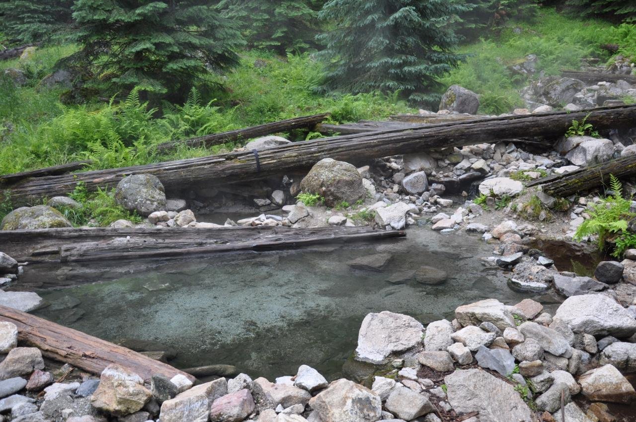
Stanley Hot Springs is a series of thermal springs in the Selway-Bitterroot Wilderness, about five miles up Boulder Creek from the Lochsa River. The trail climbs steadily along an open hillside above the creek, then crosses the creek to reach the springs. Wikipedia lists the water emerging at 106°F.
It’s a moderate overnight with an unusual reward: a soak at the end of the day, with campsites nearby.
The hike
The trip starts at Wilderness Gateway Campground on U.S. 12. Wikipedia says it’s about 26 miles past Lowell heading toward Lolo Pass, with trailhead parking past the A and B loops. Recreation.gov describes the campground as giving direct access to the Wild and Scenic Lochsa River and lists several wilderness trails leaving from it, including the 27-mile Boulder Creek Trail. The hot springs are reached via Trail #211.
River Dance Lodge describes the route: Trail 211 climbs a few switchbacks and then crosses a hillside well above Boulder Creek. After about two miles you enter the Selway-Bitterroot Wilderness. It notes there’s not much shade on the trail, but good views up and down the wide river valley, and recommends an early start. River Dance Lodge gives the round trip as about 10 miles with 1,620 feet of climbing and calls it moderately difficult. A camper review on The Dyrt puts it just under five miles one way with about 1,500 feet of gain.
Recreation.gov notes that Boulder Creek cascades down into the campground from the wilderness. Elk, deer, moose, bear, cougar, and mountain goats all live in this steep canyon country, according to the same listing.
The crossing of Boulder Creek is the key obstacle. Wikipedia says the bridge washed out in the winter of 1998–99 and the Forest Service hadn’t said it would rebuild it. As of 2021, Wikipedia describes fording the creek or heading slightly downstream to a log jam that forms a bridge to a center island, then using a log with a rope strung across for the second half. Check current conditions before you rely on that crossing. Wikipedia says the best time to visit is after spring runoff and before heavy snow.
Wikipedia gives the springs’ elevation as 3,583 feet. The Dyrt reviewer found plenty of campsites around and near the springs.
For a longer trip, the Idaho Trails Association describes a loop of about 20 miles from Wilderness Gateway. It climbs Trail 220 over the Lochsa Peak ridge toward Lottie Lake and the Seven Lakes Basin, then drops about 1,500 feet on Trail 221/2210 to the hot springs and returns down Trail 211. The association warns that those upper trails hadn’t been recently cleared beyond about a mile past the wilderness boundary, so conditions could be challenging.
The Lochsa Historical Ranger Station, a living history visitor center, is about a mile southwest of the campground, according to Recreation.gov. The Idaho Trails Association calls it well worth a visit, along with other hot springs off U.S. 12. For a longer river trip in the same wilderness, see the Selway River Trail.
Tips
- Start early. River Dance Lodge says the trail has little shade.
- Check the creek crossing. The bridge over Boulder Creek has been out since 1998–99, according to Wikipedia. Don’t cross in high water.
- Time your visit. Wikipedia says the best time is after spring runoff and before heavy snow.
- Hang your food. The Dyrt reviewer reminds campers they’re in bear territory and recommends hanging food and carrying bear spray.
- Soak responsibly. Keep soap and food out of the pools, and pack out everything you bring.
Camping
Camping is dispersed near the springs. The Forest Service says no permit is needed for general non-commercial access to the Selway-Bitterroot Wilderness, and groups are limited to 20 people and 20 stock animals. Motorized and mechanized travel, including bikes, is prohibited. The Dyrt reviewer says water can be filtered from the nearby creek and recommends hanging food in a tree. Wilderness Gateway Campground, at the trailhead, has dozens of sites.
Inside Intel: One camper who made the trip called it a wilderness camp with a hot springs soak and said there are plenty of campsites around and near the springs. River Dance Lodge’s advice is to get an early start, since the climb has little shade, which also leaves daylight to find a site and cross the creek.
Trail facts
- Distance: About 10 miles round trip
- Route type: Out and back (a longer, less-maintained loop via Lochsa Peak is possible)
- Difficulty: Moderate
- Elevation: About 1,500 to 1,620 feet of gain. Springs at about 3,583 feet (Wikipedia).
- Campsites: Dispersed, around and near the springs
- Water: Boulder Creek. Treat all water.
- Permits: None required for general non-commercial wilderness use (Forest Service)
- Group size: 20 people and 20 stock (Forest Service)
- Bear and food storage: Bear country. Hang food and carry bear spray.
- Hazards: Boulder Creek crossing with no bridge; little shade
- Trailhead: Wilderness Gateway Campground, Trail #211, off U.S. 12 east of Lowell
- Last verified: September 28, 2026
Where this comes from
This page draws on the sources below, along with other guides and trip reports. Links go to the original pages.
- Wikipedia: Stanley Hot Springs
- Recreation.gov: Wilderness Gateway
- U.S. Forest Service: Boulder Creek Trailhead (Selway-Bitterroot Wilderness rules)
- Idaho Trails Association: Trail Spotlight, Lochsa Peak
- River Dance Lodge: Hiking
- The Dyrt: Stanley Hot Springs review
Before you go: This page is based on published trail guides, trip reports, and reviews, along with official park and agency information where we could find it. It’s meant to help backpackers discover new trails, not to replace current, official information. Conditions, closures, permits, campsites, and water sources change, and some details here may be out of date or wrong. Confirm everything with the managing agency and check current conditions before you head out, and don’t rely on this page alone for safety or navigation. Backcountry travel involves risk.