
Trails / Idaho / Selway-Bitterroot
Selway River Trail
Selway-Bitterroot Wilderness, Nez Perce-Clearwater and Bitterroot National Forests (Race Creek near Lowell to Paradise near Darby, Montana)
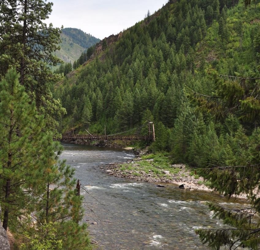
The Selway River Trail follows a river Backpacker calls one of the most pristine waterways in the Lower 48 for about 50 miles through the Selway-Bitterroot Wilderness. River trips on this stretch need a hard-to-get permit, but Backpacker notes that hikers can walk it without one. Most of the way, the trail stays close to the water, climbing over rocky headlands and dropping back to the river.
You can hike it end to end with a long car shuttle, or go in from the Idaho side at Race Creek and turn around when you like.
The hike
The western trailhead is at Race Creek Campground, at the end of Selway River Road #23. Trail Run Project describes the road as about 20 miles of well-maintained gravel from U.S. 12 at Lowell. On the way in you pass Selway Falls. River Dance Lodge says the falls are most spectacular in spring high water and that in mid-to-late June you can see salmon jumping. It also says the trail enters the Selway-Bitterroot Wilderness about two miles from Race Creek.
The Idaho Trails Association calls the Selway one of the nation’s first designated Wild and Scenic Rivers. It rates the trail 2 out of 5 in difficulty but warns it gets brushy in places, muddy in spring, and steep where it rounds the headlands above the river. Trail Run Project describes countless ups and downs, from right beside the river to high above it. Many side creeks cross the trail, and the larger ones are bridged. Backpacker says the trail crosses the river itself twice on suspension bridges.
Moose Creek is the landmark in the middle. River Dance Lodge puts it about 25 miles from Race Creek. The Whitewater Guidebook says Moose Creek often doubles the river’s flow where it joins. It also says trails from nearby campsites lead to the Moose Creek Ranger Station, the Shissler Peak Fire Lookout, and up Moose Creek. American Whitewater notes an airstrip there. Just below the confluence, the river enters a series of rapids that boaters call the “Moose Juice,” including Ladle Rapid. The Backpacker writers camped at Ladle Falls and could barely talk over the roar.
The eastern trailhead is at Paradise Campground, reached from Montana. The Idaho Trails Association says the last 50 miles on Road #468 are a long dirt drive of about two hours, past the West Fork Ranger Station south of Darby. The road isn’t plowed, and snow can fall at almost any time over Nez Perce Pass. It says the shuttle between trailheads takes about six hours and should go by way of U.S. 12, not the Magruder Corridor Road. Backpacker mentions river companies that can run the shuttle.
Heat and snakes shape the season. Trail Run Project says rattlesnakes are typically active from early May into fall, and Backpacker calls midsummer sweltering, suggesting hiking early and late in the day. Trail Run Project describes ridges rising more than 4,000 feet above the river, dense pine forest, and rapids up to Class IV+ during the spring melt.
Backpacker describes camping on the riverbank on the first night, dangling their feet in the current under moonlight. In the lower reaches, the river calms, and trout flash in the shallows. For a shorter trip into the same wilderness, see Stanley Hot Springs.
Tips
- Plan the shuttle. The Idaho Trails Association says the drive between trailheads takes about six hours via U.S. 12. Don’t use the Magruder Corridor Road.
- Beat the heat. Backpacker calls midsummer sweltering and suggests hiking early and late.
- Watch for rattlesnakes. Trail Run Project says they’re active from early May into fall.
- Respect private land and stock. Backpacker says to respect private in-holdings and packhorses along the trail, and notes a few unsigned trail crossings.
- Bring a spare tire for the Paradise end. The Idaho Trails Association recommends one for the long dirt road.
Camping
Camping is dispersed along the river. The Forest Service says no permit is needed for general non-commercial access to the Selway-Bitterroot Wilderness, and that groups are limited to 20 people and 20 stock animals. Motorized and mechanized travel, including bikes, is prohibited in the wilderness. Store food securely; bears live here.
Inside Intel: One rafting guide says most campsites along this stretch are right on the Selway Trail. It recommends Tony Point Camp near Moose Creek as a base, since trails from there reach the Moose Creek airstrip, the ranger station, and the Shissler Peak Lookout. The Backpacker writers found their best night on a riverbank where they could dangle their feet in the water. If you camp near Ladle Falls, expect it to be loud.
Trail facts
- Distance: About 50 miles one way (43 to 53, depending on the source). About 25 miles from Race Creek to Moose Creek.
- Route type: Point to point with a shuttle, or out and back from either end
- Difficulty: Strenuous overall for length and heat; the Idaho Trails Association rates the grade 2 out of 5
- Elevation: Low point about 1,765 feet; high point about 3,075 feet (Trail Run Project)
- Campsites: Dispersed riverside sites, including near Moose Creek and Ladle Falls
- Water: The river and side creeks. Treat all water.
- Permits: None required for hiking, per the Forest Service and Backpacker. River trips need a separate permit.
- Group size: 20 people and 20 stock (Forest Service)
- Hazards: Rattlesnakes, heat, high water in spring
- Trailheads: Race Creek Campground (Idaho, end of Selway River Road #23 from Lowell); Paradise Campground (reached from Darby, Montana, via Road #468)
- Last verified: September 28, 2026
Where this comes from
This page draws on the sources below, along with other guides and trip reports. Links go to the original pages.
- Idaho Trails Association: Trail Spotlight, Selway River Trail #4
- U.S. Forest Service: Boulder Creek Trailhead (Selway-Bitterroot Wilderness rules)
- Backpacker: Hike Idaho’s Selway-Bitterroot Wilderness
- Trail Run Project: Selway River Trail
- River Dance Lodge: Hiking
- Whitewater Guidebook: Selway River
- Outbound: Whitewater raft the Selway River
Before you go: This page is based on published trail guides, trip reports, and reviews, along with official park and agency information where we could find it. It’s meant to help backpackers discover new trails, not to replace current, official information. Conditions, closures, permits, campsites, and water sources change, and some details here may be out of date or wrong. Confirm everything with the managing agency and check current conditions before you head out, and don’t rely on this page alone for safety or navigation. Backcountry travel involves risk.