
Haleakalā via Kaupō Gap (Keoneheʻeheʻe to Palikū and down the Kaupō Trail)
Haleakalā National Park and Kaupō ranch lands (East Maui)
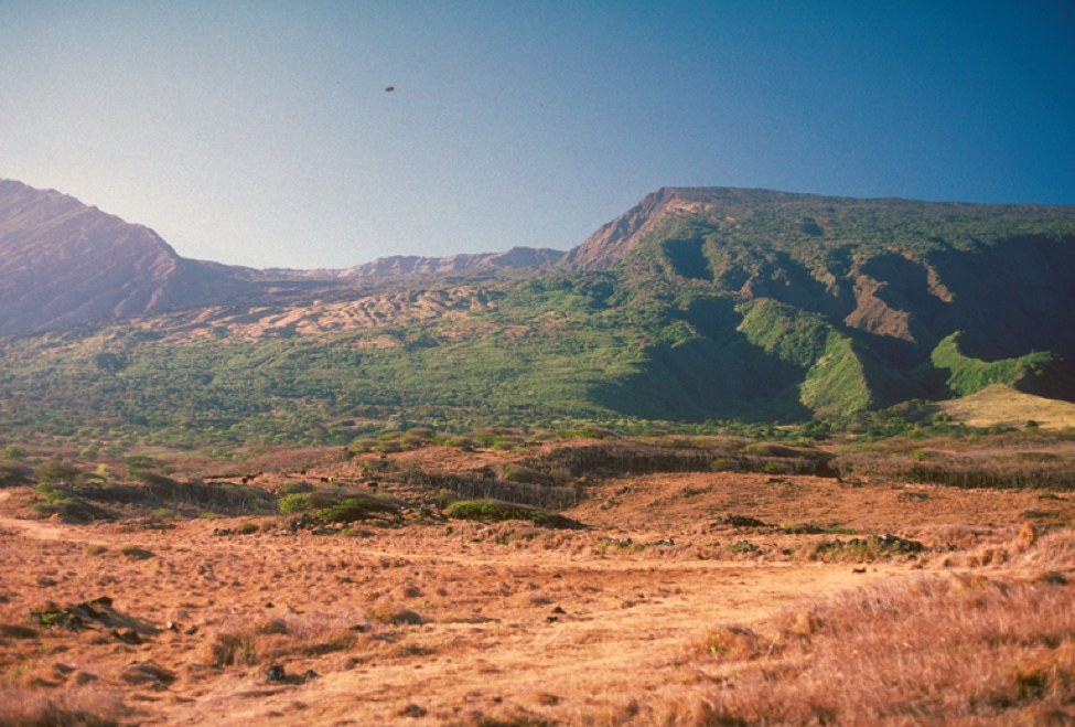
Most crater trips at Haleakalā start and end on the summit. This one drops off the mountain instead. From Palikū, at the crater’s foggy east end, the Kaupō Trail descends through Kaupō Gap, out of the national park, and down across ranch land toward Maui’s southeast coast, losing more than 5,000 feet. Combined with the Keoneheʻeheʻe (Sliding Sands) Trail from the summit, it makes a one-way traverse of the volcano, with a night or two at Palikū.
It needs a car shuttle or pickup at the bottom, and the lower trail is rough and can be hard to follow.
The hike
The first day is the standard descent into the crater. NPS puts Palikū 9.3 miles from the summit trailhead via Keoneheʻeheʻe, and The Hiking HI describes about 3,000 feet of descent through red sand and spatter cones to Kapalaoa Cabin, then black lava and greener ground near Palikū. Recreation.gov describes Palikū, at 6,380 feet, as sitting at the base of a rain-forest cliff where clouds and fog often roll over.
From Palikū, the Kaupō Trail heads south through the gap. Hiking Project lists it at 6.9 miles, falling from 6,373 feet to 968 feet with about 5,400 feet of elevation change at a 15 percent average grade. It describes steep, brushy terrain, switchbacks, rocky sections, and ocean views reaching to the Big Island, and calls the trail “a strenuous undertaking through beautiful rainforest, most suitable for experienced backpackers.”
SummitPost puts the national park boundary 3.1 miles above the lower trailhead (Joseph Bullough’s report says about 3.5). Below it, the trail crosses ranch land. Hiking Project says the trail passes a fence line onto private ranch property, where hikers have permission to continue and should “be respectful.” Andrew Lavigne, describing a 2012 trip, says NPS placed trail posts through that section under an access arrangement. Bullough describes “vague tracks of jeep roads” and cattle on the hillsides. In a 2015 comment on SummitPost, one hiker reported that marker posts in the switchgrass “point you in the wrong direction” and that animals had made confusing side trails.
Hiking Project says the trail ends at Kaupō Gap Road, with several more miles of road walking to Highway 31. SummitPost puts the regular trailhead 1.45 miles up the road from the Kaupō Store and says some hikers continue 0.8 mile below the store to the shoreline. Lavigne and Bullough both started at the ocean to climb sea to summit, the reverse of this trip.
SummitPost warns of rapid swings from tropical to near-subarctic weather on the full route, and of wild boars. Hiking Project adds that the cold, the altitude, and the sun cause rapid dehydration and fatigue.
For the classic summit-to-summit crossing, see Haleakalā’s crater traverse.
Tips
- Arrange your ride. SummitPost recommends a shuttle vehicle at the bottom; Hiking Project says most hikers arrange a one-way pickup.
- Carry water. SummitPost says there’s no water along the route, and Palikū’s spigot must be treated and can run dry in drought.
- Bring all your food. Hiking Project notes there’s no food available inside the park.
- Expect route-finding below the boundary. Markings can be vague in the lower sections.
- Respect the ranch land. Stay on the route and confirm current access with the park.
- Save your knees. The Kaupō Trail loses about 5,400 feet; trekking poles help.
Camping
Camping is at the Palikū wilderness tent area, by NPS permit on Recreation.gov only; NPS says no in-person reservations or pickup are available. Palikū has four individual sites (up to 5 people and 2 tents each) and one group site (up to 10 people and 4 tents), a pit toilet, and a non-potable water spigot outside the cabin. Stays are limited to three consecutive nights, and all overnight camping is limited to three nights per 30-day period. The Palikū cabin is reserved separately; a tent permit doesn’t include it. Pets aren’t allowed on park trails.
Inside Intel: The Hiking HI found Palikū the more established of the two crater camps, with water close to the tents, but says it’s popular, so you may share space. Hiking Project calls the Palikū cabin a popular overnight stop for this route. Plan for cool, damp nights: Recreation.gov calls Palikū “exceptionally cool and lush.”
Trail facts
- Distance: About 18 miles one way: 9.3 miles to Palikū via Keoneheʻeheʻe, then about 6.9 miles on the Kaupō Trail plus road walking below it
- Route type: Point-to-point
- Difficulty: Strenuous; long descent, rough lower trail
- Elevation: About 3,000 feet down into the crater; about 5,400 feet down on the Kaupō Trail (6,373 to 968 feet, Hiking Project)
- Campsites: Palikū wilderness tent area (6,380 feet); Palikū cabin by separate reservation
- Water: Non-potable spigot at Palikū (treat; may be dry in drought); none on the Kaupō Trail
- Permits: NPS wilderness tent permit, Recreation.gov only
- Dogs: Not allowed on park trails
- Trailheads: Keoneheʻeheʻe at the summit visitor center; Kaupō Trail’s lower end off Highway 31 near the Kaupō Store
- Last verified: October 6, 2026
Where this comes from
This page draws on the sources below, along with other guides and trip reports. Links go to the original pages.
- National Park Service: Haleakalā wilderness camping
- Recreation.gov: Haleakalā Wilderness Tent Permit
- Maui Now: Haleakalā reopens after Nolo
- Maui Now: Funds for acquisition of Kaupō Ranch (2022)
- Kamehameha Schools: Acquisitions on Maui that include Kaupō Ranch lands
- Hiking Project: Kaupo Trail
- SummitPost: Kaupo Gap Trail
- SummitPost: From Sea to Summit
- Andrew Lavigne: Haleakalā Sea-to-Summit Climb (2012)
- The Hiking HI: Haleakalā Crater Backpacking
Before you go: This page is based on published trail guides, trip reports, and reviews, along with official park and agency information where we could find it. It’s meant to help backpackers discover new trails, not to replace current, official information. Conditions, closures, permits, campsites, and water sources change, and some details here may be out of date or wrong. Confirm everything with the managing agency and check current conditions before you head out, and don’t rely on this page alone for safety or navigation. Backcountry travel involves risk.