
Trails / Georgia / North Georgia Mountains
Jacks River Trail to Jacks River Falls (Cohutta Wilderness)
Cohutta Wilderness, Chattahoochee National Forest, Conasauga Ranger District (Dally Gap to Alaculsy Valley, near Chatsworth)
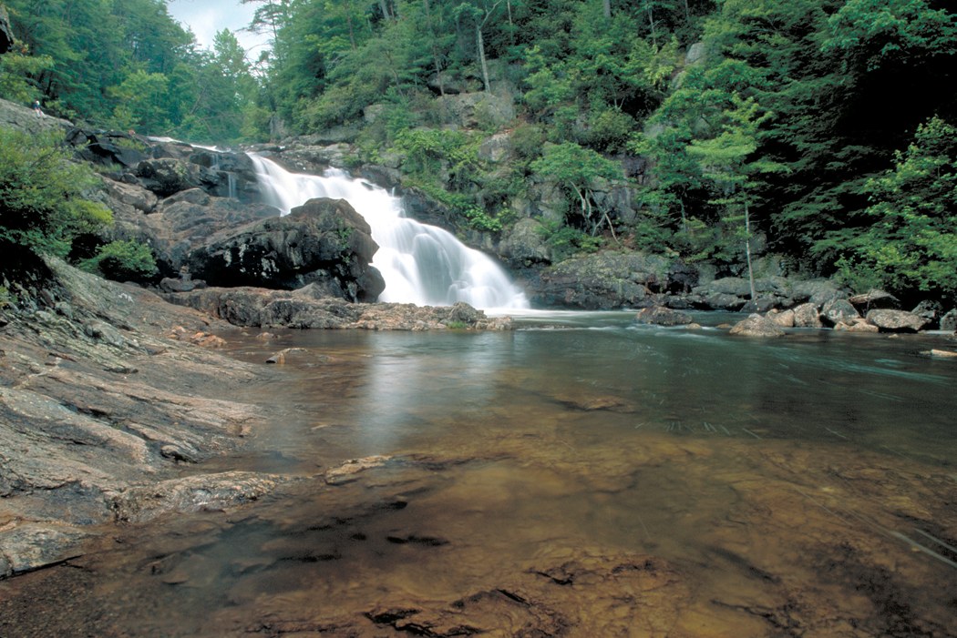
The Jacks River Trail runs through the heart of the Cohutta Wilderness in North Georgia, following the river from its headwaters near Dally Gap down to Alaculsy Valley. Along the way are an 80-foot, two-tiered waterfall, Jacks River Falls, and 40-plus river crossings. Celebrate Blue Ridge calls it the longest and wettest trail in the Cohutta, and Backpacker calls the falls incredible.
High water can make the crossings dangerous, and camping near the falls is restricted for most of the year.
The hike
Celebrate Blue Ridge says the Jacks River Trail runs 16.7 miles from Dally Gap with 42 fords, and that Jacks River Falls, at mile 9.2, is the most visited single feature in the Cohutta Wilderness. Backpacker describes a 16.3-mile shuttle hike with more than 43 water crossings, the first coming within 0.2 mile. Atlanta Trails puts the falls 9 miles north of the Dally Gap trailhead.
Backpacker describes the route: past a point where the trail meets the river at an island, ford the Jacks, hugging the downstream tip of the island, with many campsites ahead. It warns that after heavy rainfall, the crossings become more complicated and can be dangerous. One Jacks River crossing marks the edge of the no-camping zone for the falls area, and the restricted camping area ends roughly a mile below the falls.
Jacks River Falls itself is the centerpiece. Atlanta Trails describes it as a stunning, roaring, rocky waterfall, and Celebrate Blue Ridge calls it an impressive 80-foot, two-tier fall. Below the falls, Backpacker says, the trail meets one of its trickier crossings, across an island in the middle of the river, and there are no campsites from there to the western end.
Celebrate Blue Ridge notes that the Georgia Wilderness Bill of 1986 added 2,940 acres to the Cohutta Wilderness, and that although much of the area was logged early in the last century, the forest has returned. Hiking the Appalachians and Beyond calls the Jacks River the second-largest waterway in the combined Cohutta and Big Frog Wilderness.
The Beech Bottom Trail is a shorter, drier approach. Atlanta Trails describes it starting in Tennessee and descending to the river without crossing the Jacks, though it crosses a few side streams. Hiking the Appalachians and Beyond calls it a good winter alternative because it’s relatively dry, though Beech Bottoms Creek can be a problem in high water.
The camping rules center on the falls. The Forest Service’s orders page lists its Cohutta Wilderness camping restriction as running April 12, 2012 through April 12, 2017, so confirm with the Conasauga Ranger District whether it still applies. That order says camping in the vicinity of Beech Bottom and Jacks River Falls is restricted to designated campsites from November 1 to March 31. Other sources describe camping there as banned from April 1 to October 31 because of ecological damage. A forum post quoting the regulations says campfires and alcohol are prohibited in the Jacks River Falls area. Atlanta Trails asks hikers to follow posted signs and warns that group sizes and camping are limited because of the waterfall’s popularity.
Elsewhere along the river, campsites are plentiful. An AllTrails reviewer recommends an excellent spot past the Rice Camp Trail near the river. The Dyrt describes a group campsite on a small island-like area near the falls that easily held a group of 10, though it’s within the seasonal restriction zone.
For another Southern Appalachian trip, see the Appalachian Trail from Amicalola Falls to Woody Gap.
Tips
- Don’t cross in high water. Backpacker warns crossings can be dangerous after heavy rain.
- Wear shoes you can wade in. There are more than 40 fords.
- Know the falls-area rules. Camping has been restricted near Beech Bottom and the falls; the Forest Service lists that order as 2012 to 2017, so ask the Conasauga Ranger District what applies now.
- No campfires near the falls. Sources say fires are prohibited there.
- Use Beech Bottom for a drier approach. It’s the only relatively dry route to the falls.
Camping
Camping is dispersed in the Cohutta Wilderness, with restrictions near Beech Bottom and Jacks River Falls. The Forest Service limits camping there to designated campsites from November 1 to March 31, and other sources describe it as closed to camping the rest of the year. Campfires and alcohol are reportedly prohibited in the falls area. Outside the restricted zone, Backpacker describes many campsites along the river.
Inside Intel: Camp outside the falls zone and visit it by day. An AllTrails reviewer points to an excellent spot past the Rice Camp Trail near the river, and Backpacker notes many campsites after the island crossing above the falls. Below the falls, Backpacker says, there are no campsites to the western end, so plan accordingly.
Trail facts
- Distance: About 16.3 to 16.7 miles, Dally Gap to Alaculsy Valley; Jacks River Falls about 9 miles from Dally Gap
- Route type: Point to point, or out and back
- Difficulty: Strenuous; 40 or more river crossings
- Campsites: Dispersed along the river; check current rules near Beech Bottom and the falls
- Water: Jacks River and tributaries. Treat all water.
- Permits: None found
- Hazards: Fords that become dangerous in high water
- Trailheads: Dally Gap (Forest Service Road 22); Alaculsy Valley; Beech Bottom (Tennessee)
- Last verified: October 2, 2026
Where this comes from
This page draws on the sources below, along with other guides and trip reports. Links go to the original pages.
- U.S. Forest Service: Chattahoochee-Oconee Forest Supervisor’s Orders
- Backpacker: Cohutta Wilderness Area, Jacks River Trail
- Atlanta Trails: Jacks River Falls on the Beech Bottom Trail
- Hiking the Appalachians and Beyond: Jacks River Falls via Rice Camp Loop
- Hiking the Appalachians and Beyond: Beech Bottoms Trail to Jacks River Falls
- AllTrails: Jacks River Trail to Beech Bottom
- Celebrate Blue Ridge: Jacks River Trail (PDF)
- The Dyrt: Jacks River Falls group camp
Before you go: This page is based on published trail guides, trip reports, and reviews, along with official park and agency information where we could find it. It’s meant to help backpackers discover new trails, not to replace current, official information. Conditions, closures, permits, campsites, and water sources change, and some details here may be out of date or wrong. Confirm everything with the managing agency and check current conditions before you head out, and don’t rely on this page alone for safety or navigation. Backcountry travel involves risk.