
Trails / Alaska / Wrangell-St. Elias
Root Glacier Trail and Jumbo Creek Camping Area
Wrangell-St. Elias National Park and Preserve, National Park Service (Kennecott, near McCarthy)
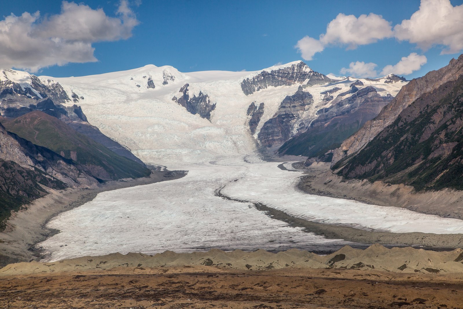
The Root Glacier Trail leaves the historic Kennecott Mill Town in Wrangell-St. Elias National Park and follows the edge of the Root Glacier toward the Stairway Icefall. About 2 miles from the visitor center, near where Jumbo Creek comes down from the mountains, the Park Service maintains a primitive camping area with bear-resistant food boxes and an outhouse.
The NPS rates the trail easy to moderate, and the camp makes a base for day hikes to old mines.
The hike
Getting there is part of the trip. The NPS says Kennecott is reached from McCarthy, at the end of the McCarthy Road, by walking the road between them (an extra 4.5 miles), taking a commercial shuttle, or riding a bike.
The NPS Root Glacier/Erie Mine Trail handout describes the route. From the Kennecott Visitor Center, walk north through the mill town toward the Root Glacier. About half a mile past the visitor center, the road splits; the other branch leads to the Jumbo and Bonanza Mines. The trail soon crosses Bonanza Creek and Jumbo Creek. The NPS rates it easy to moderate, with relatively level terrain and moderate elevation gain and loss, and lists glacier viewing, mining artifacts, and views of Mount Blackburn, Regal Mountain, and Donoho Peak as highlights.
The NPS Donoho Basin handout says that after about another quarter mile, the trail reaches the Root Glacier access trail, where primitive campsites, an outhouse, and food lockers are available. A sign marks the fork. Turning left leads down the moraine to the toe of the glacier. The NPS handout lists the round trip from Kennecott to the glacier at 4 miles.
The NPS warns that the trail is not a route to the Erie Mine. The primitive trail continues alongside the Root Glacier for about 4 miles one way from Kennecott and ends where cables from the Erie Mine descend from the hillside, with the Stairway Icefall looming close. But in fall 2023, the NPS reported that a landslide washed out a significant portion of that trail several miles in.
Day hikes from the camping area lead into mining history. The NPS lists the Jumbo Mine Trail as a strenuous day hike to panoramic views and the remains of the Jumbo Mine bunkhouse. Its Kennecott map says the Jumbo hike can seem harder than the Bonanza Mine trail because of a wet creek crossing half a mile from the junction.
Longer trips from here require more skill. The NPS says continuing across the Root Glacier to Erie Lake, or into Donoho Basin between the Root and Kennicott Glaciers, requires glacier travel experience and equipment. Indigo Alpine Guides adds that from McCarthy, backpackers generally head east toward Nikolai Pass or north across the Root Glacier toward Glacier Gulch.
The NPS is emphatic about food storage. Throughout the park, it says, all food, beverages, garbage, and cooking gear must be stored in a bear-resistant container or a hard-sided building or vehicle. Its Kennecott map advises cooking and storing all food at least 100 yards from your tent.
For another Alaska trip rich in mining history, see the Chilkoot Trail (U.S. side).
Tips
- Bring or borrow a bear canister. The NPS says bear-resistant food containers are required for all backcountry camping in the park. The Kennecott map says you can check out a free one at the Kennecott Visitor Center.
- Cook away from your tent. The NPS recommends cooking and storing food at least 100 yards away.
- Stay off the glacier without training. The NPS says glacier travel beyond the toe requires experience and equipment.
- Check the Erie Mine Trail status. A 2023 landslide washed out part of it.
- Plan the McCarthy logistics. You’ll walk, bike, or shuttle the 4.5 miles from McCarthy to Kennecott.
Camping
The NPS says primitive campsites, an outhouse, and food lockers are available near the Root Glacier access trail, in what its map calls the Jumbo Creek Camping Area. The NPS lists two bear-resistant food boxes in the Jumbo Creek area. It says campers are still required to use an approved bear-resistant food container, and Indigo Alpine Guides says you can rent one from the park for free. Talk with a ranger at the Kennecott Visitor Center about current conditions.
Inside Intel: We didn’t find camper accounts recommending particular sites here. From the NPS descriptions, the Jumbo Creek camping area is the easy overnight, about 2 miles from Kennecott with toilets and food boxes, per the NPS. From camp, you can walk to the toe of the Root Glacier the same evening and head up to the Jumbo or Bonanza Mines the next day. If you have glacier skills and gear, Indigo Alpine Guides points to routes across the Root Glacier toward Glacier Gulch, but those go well beyond this trail.
Trail facts
- Distance: About 4 miles round trip from Kennecott to the glacier and camping area; 8 miles round trip to the Erie Mine cables (check trail status)
- Route type: Out and back
- Difficulty: Easy to moderate (NPS)
- Campsites: Primitive campsites at the Jumbo Creek camping area, with an outhouse and bear boxes
- Water: Creeks; Amazon Creek is seasonal (NPS). Treat all water.
- Permits: None found for this camping area
- Also in the park: Most backpacking in Wrangell-St. Elias is off-trail; the NPS says many routes need advanced skills
- Bear and food storage: Bear-resistant food containers required throughout the park
- Glacier travel: Requires experience and equipment beyond the toe
- Trailhead: Kennecott Visitor Center, Kennecott Mill Town (reached from McCarthy)
- Last verified: September 28, 2026
Where this comes from
This page draws on the sources below, along with other guides and trip reports. Links go to the original pages.
- National Park Service: McCarthy Road and Kennecott Trails
- National Park Service: Backpacking in Wrangell-St. Elias
- National Park Service: Root Glacier/Erie Mine Trail handout (PDF)
- National Park Service: Donoho Basin handout (PDF)
- National Park Service: Kennecott Hiking and Food Storage Map (PDF)
- National Park Service: Food Storage Requirements
- Indigo Alpine Guides: Backpacking Wrangell-St. Elias
Before you go: This page is based on published trail guides, trip reports, and reviews, along with official park and agency information where we could find it. It’s meant to help backpackers discover new trails, not to replace current, official information. Conditions, closures, permits, campsites, and water sources change, and some details here may be out of date or wrong. Confirm everything with the managing agency and check current conditions before you head out, and don’t rely on this page alone for safety or navigation. Backcountry travel involves risk.