
Trails / Alaska / Southeast Alaska
Chilkoot Trail (U.S. Side)
Klondike Gold Rush National Historical Park, National Park Service (Dyea, near Skagway)
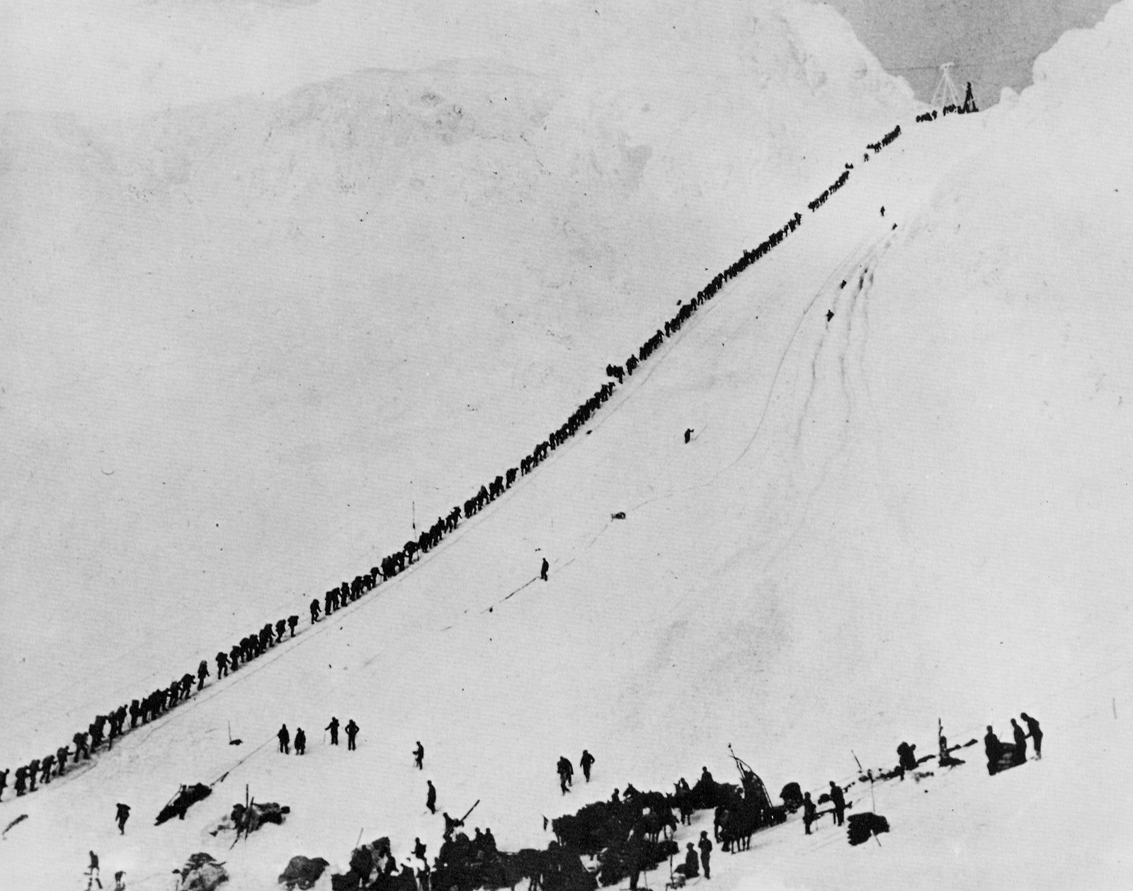
The Chilkoot Trail is the Gold Rush route that, as Hiking Project puts it, thousands of gold seekers took in the winter of 1897–98, from tidewater at Dyea toward the Yukon gold fields. Normally it’s a 33-mile international hike ending at Bennett, British Columbia. For now, the National Park Service says the trail isn’t open for crossing the border, so hikers on the U.S. side go up to the border at Chilkoot Pass and come back.
Treeline Review calls it a backpacking route steeped in history, with Gold Rush remnants along the way and the famous Golden Stairs at the top.
The hike
The NPS describes the Chilkoot as a 33-mile international trail from Dyea, Alaska, to Bennett, British Columbia, with nine campgrounds and about 3,500 feet of elevation gain overall. Chilkoot Pass roughly marks the halfway point and the border. Wikipedia says the trail and the Dyea site became a National Historic Landmark in 1978, and that the U.S. and Canadian parks together form Klondike Gold Rush International Historical Park.
The trail starts near the ghost town of Dyea, outside Skagway. Hiking Project describes it as well marked and maintained, following the Taiya River through coastal rainforest until the climb begins beyond Sheep Camp. Treeline Review puts Finnegan’s Point, the first camp, at mile 4.8.
The U.S.-side campgrounds follow the river. The NPS lists Finnegan’s Point, Canyon City, Pleasant Camp, and Sheep Camp on the U.S. side. It describes Pleasant Camp as one of the least crowded, and Sheep Camp as having the backcountry ranger station, an evening ranger chat, and hiker shelters. An Alaska Hike Search writer says Canyon City has a large old log cabin hikers can share to dry out, cook, and warm up. Treeline Review mentions crossing an iconic suspension bridge on the way to Sheep Camp.
Recreation.gov places Sheep Camp at about mile 13 and 1,058 feet, with 25 wooden tent platforms, a covered open-air picnic shelter, a restored 1960s log cabin with a wood stove, bear boxes, and three composting outhouses. It notes that sleeping in the shelters isn’t allowed and that water comes from the nearby Taiya River and must be purified.
Above Sheep Camp comes the big climb. The Alaska Hike Search writer says the first 2.5 miles, called Long Hill, climb steadily through subalpine and alpine terrain into boulder and snow fields. Long Hill ends at The Scales, where Gold Rush stampeders had their gear weighed. The last mile to the summit is the Golden Stairs. Treeline Review warns about slippery boulders on the approach. Sources put the climb from Sheep Camp to the pass at 2,500 to 3,000 feet in about 3.5 miles.
With the border closed to crossing, Chilkoot Pass is the turnaround. Beyond it, on the Canadian side, lie Happy Camp, Deep Lake, Lindeman City, Bare Loon, and Bennett, which the NPS says is reachable only by train, air taxi, or boat.
Wikipedia notes that the NPS and Parks Canada limit starts to 50 backpackers a day to manage demand and protect the trail’s remote character. Hiking Project calls the whole trail a national historic site and says a ranger is always stationed at Sheep Camp to offer tips for the day over the pass.
Tips
- Get a permit and orientation. The NPS says U.S.-side permits are reserved on Recreation.gov and validated at the Chilkoot Trail Center in Skagway with a mandatory safety briefing.
- Plan to turn around at the border. Crossing into Canada is currently prohibited, per the NPS.
- No cell service. The NPS says there’s none anywhere on the trail.
- No campfires. Recreation.gov says open fires are prohibited on the Chilkoot Trail. Bring a stove.
- Use the bear boxes. Every U.S. campground has bear boxes, and the NPS asks hikers to stay bear aware at all times.
- Use the tent pads. Recreation.gov says tent pads must be used at Finnegan’s Point, Canyon City, and Sheep Camp.
Camping
The NPS says a permit is required for all overnight camping, and backcountry camping is allowed only in the developed campgrounds along the trail. When you apply, you choose which campground you’ll stay at each night. Your permit guarantees a site in that campground, and individual sites are first come, first served. Food storage is in bear boxes. Front-country camping is available at the Dyea campground near the trailhead.
Inside Intel: Sheep Camp is the key stop. An Alaska Hike Search writer calls it a really indispensable stop before the summit day, and the NPS says it has the backcountry ranger station and an evening ranger chat. If you want quiet on the way up, the NPS calls Pleasant Camp one of the least crowded campgrounds, and Recreation.gov suggests it for experienced hikers used to long days who want a quieter night than Sheep Camp. The Canyon City log cabin is where hikers dry out on wet days.
Trail facts
- Distance: About 33 miles round trip from Dyea to Chilkoot Pass and back (the full international trail is 33 miles one way, currently not open for border crossing)
- Route type: Out and back on the U.S. side
- Difficulty: Strenuous. The final climb to the pass is steep, rocky, and often snowy.
- Elevation: About 2,500 to 3,000 feet of climbing in the 3.5 miles from Sheep Camp to the pass
- Campsites: Designated campgrounds only: Finnegan’s Point, Canyon City, Pleasant Camp, and Sheep Camp on the U.S. side
- Water: Taiya River and streams. Treat all water.
- Permits: Required for overnight use, about June 1 to September 12. Reserve on Recreation.gov; validate in Skagway.
- Fires: Prohibited
- Bear and food storage: Bear boxes at campgrounds
- Trailhead: Chilkoot Trailhead at Dyea, near Skagway
- Last verified: September 28, 2026
Where this comes from
This page draws on the sources below, along with other guides and trip reports. Links go to the original pages.
- National Park Service: Chilkoot Trail Campgrounds
- National Park Service: Permits and Reservations
- National Park Service: Guide to Planning Your Hike
- Recreation.gov: Chilkoot Trail Camping Permits
- Wikipedia: Chilkoot Trail
- Treeline Review: Chilkoot Trail guide
- Alaska Hike Search: Chilkoot Trail
Before you go: This page is based on published trail guides, trip reports, and reviews, along with official park and agency information where we could find it. It’s meant to help backpackers discover new trails, not to replace current, official information. Conditions, closures, permits, campsites, and water sources change, and some details here may be out of date or wrong. Confirm everything with the managing agency and check current conditions before you head out, and don’t rely on this page alone for safety or navigation. Backcountry travel involves risk.