
Trails / Idaho / Hells Canyon
Seven Devils Loop
Hells Canyon Wilderness, Hells Canyon National Recreation Area (Seven Devils Mountains, near Riggins)
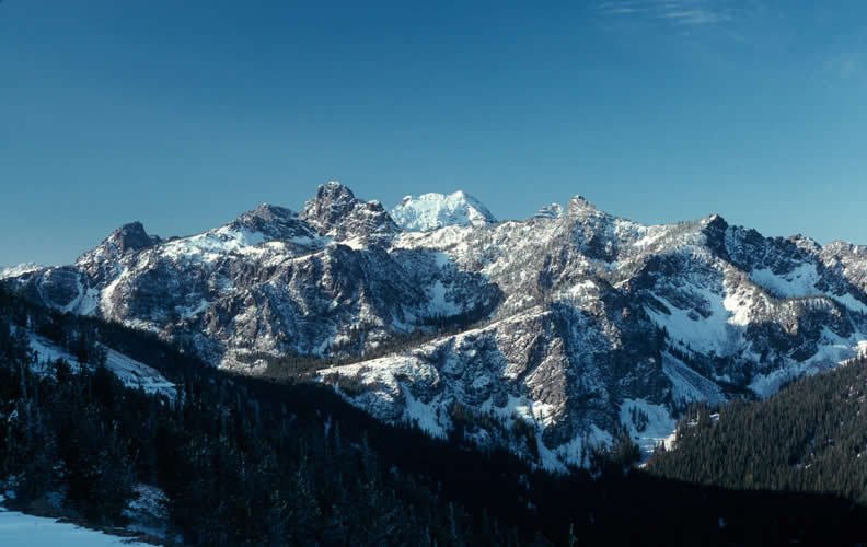
The Seven Devils are the high peaks on the Idaho side of Hells Canyon, and the Seven Devils Loop circles the range on a trail of roughly 28 miles. Along the way, side trails climb to alpine lakes tucked below the summits, and the trail passes meadows, talus fields, and old burns.
Visit Idaho’s writer found solitude to be the one constant here, but not easy walking. Heat, a long dry stretch, and blowdown make it harder than the mileage suggests.
The hike
The loop starts at Windy Saddle, which the Forest Service calls the main access point into the Hells Canyon Wilderness from Idaho. It’s 17 miles up Forest Road 517 from U.S. 95 near Riggins. Nearby, the Forest Service says, Heaven’s Gate Lookout offers views of parts of Washington, Oregon, Idaho, and Montana. An older Backpacker article calls Hells Canyon the deepest river gorge in North America, about 8,043 feet from He Devil Peak down to the Snake River.
This description follows Visit Idaho’s 2023 trip report, hiked clockwise on Seven Devils Trail #124. The writer describes dead trees and a barren landscape for the first two miles, then shade and a flowing creek just before the 3.5-mile mark. After crossing the east and west forks of Sheep Creek, the trail meets Trails #140 and #57, the latter leading toward Bernard Lakes and Dry Diggins Lookout. The onX guide says Hells Canyon itself is visible only from the start of the trail or from the side trail to Dry Diggins Lookout.
From that junction, Sheep Lake Trail #123 leads about 1.5 miles to Basin Lake, with Shelf and Gem Lakes about half a mile beyond. Sheep Lake is another two miles and, Visit Idaho says, a bit of a bushwhack. onX describes Sheep Lake as one of the larger lakes in the range, sitting at the base of He Devil and She Devil, the two highest peaks. Visit Idaho warns that an unofficial “shortcut” to Sheep Lake from Seven Devils Campground, shown on some route-sharing apps, is a hazardous scramble and the site of most rescues in the Seven Devils.
Back on the loop, the writer hit several dozen downed trees in one quarter-mile stretch before reaching Baldy Lake, about seven miles from Basin Lake. Then comes the hardest stretch. The next reliable water was nine miles away at Dog Creek, and the trail gains about 1,400 feet in the three miles after Baldy, mostly in the sun. Past Pyramid Mountain the route opens into a long alpine meadow. At the Horse Heaven junction, Trail #124 ends and the loop continues on the South Boise Trail #101A.
Dog Creek has cold water and large established camps with log benches, according to the same report. The last day passes a side trail to Lower Cannon Lake, a worthwhile 1.75-mile detour in the writer’s view, before a final mile and a half that climbs about 1,000 feet back to Windy Saddle.
The range is full of lakes. SummitPost counts about 56, and a Forest Service wildflower page says trails lead to over 90. The Big Outside says the best backcountry camping is at lakes up the side trails, such as Sheep Lake, Bernard Lakes, and He Devil Lake, so plan extra miles. The Forest Service says the cliffs around the Seven Devils Campground are good for spotting mountain goats, and the slopes between Windy Saddle and Heaven’s Gate hold some of the best wildflower viewing.
Tips
- Carry more water than you think. Visit Idaho’s writer describes a nearly nine-mile stretch in the middle of the loop with no water and says July and August bring sweltering daytime highs. She carried four liters out of Baldy Lake.
- Drive carefully. The Forest Service says Forest Road 517 is very steep and narrow and does not recommend low-clearance vehicles, RVs, or trailers on its upper sections. Visit Idaho says a 4x4 isn’t necessary. There’s no potable water at the Windy Saddle trailhead.
- Plan for blowdown. Visit Idaho says the area is notorious for downed trees after years of wildfires. Its writer had to crawl under trunks in one stretch.
- Guard your gear from critters. The same writer was warned about aggressive rodents and mountain goats, hung her pack and trekking poles at night, and met a hiker whose pole handle had been chewed nearly off.
- Skip the Sheep Lake “shortcut.” Visit Idaho says it’s an unofficial, hazardous scramble and the site of most rescues in the range.
- Timing. The Forest Service lists late June as the opening for the trailhead campgrounds. Visit Idaho’s writer went in mid-July, just after snowmelt and near peak wildflowers, and still skirted one snowfield near Pyramid Mountain.
Camping
Camping is dispersed in the Hells Canyon Wilderness. AllTrails says backpacking in this part of the wilderness requires no permit; confirm with the Forest Service office in Riggins (208-628-3916). Visit Idaho says campfires are allowed in established backcountry sites but are often restricted in summer, so check before you go. Black bears live in the Seven Devils, and Visit Idaho advises carrying bear spray, making noise, and using a bear canister or a proper bear hang. The Forest Service says motorized vehicles, bicycles, carts, and other mechanical equipment are prohibited in the wilderness.
At the trailhead, the Forest Service lists four tent campsites at Windy Saddle and 10 tent-only sites at nearby Seven Devils Campground. The Forest Service says the Windy Saddle sites are not reservable.
Inside Intel: Basin Lake is the go-to first night if you’re hiking clockwise. Visit Idaho’s writer camped there after 6.5 miles, and a second trip report describes camping at Basin and day hiking to Sheep Lake. Shelf and Gem Lakes, half a mile on, have sites too. For night two, the Visit Idaho writer found several flat campsites tucked in the woods behind Baldy Lake, many with log benches. Night three at Dog Creek has large, established camps a quarter mile from the trail junction. Looking back, she said she’d set up base camps at more accessible lakes like Baldy or Lower Cannon and spend days exploring from there.
Trail facts
- Distance: About 27 to 30 miles for the base loop, depending on the source; more with side trips to lakes
- Route type: Loop, typically three to four days. Either direction.
- Difficulty: Strenuous (heat, dry stretches, blowdown, and steep sections)
- Elevation: Windy Saddle sits around 7,700 feet (Forest Service horse camp listing). Visit Idaho’s writer logged about 5,650 feet of gain over 33 miles with side trips.
- Campsites: Dispersed. Common stops include Basin, Shelf, and Gem Lakes; Baldy Lake; and Dog Creek. Side-trail lakes such as Sheep, Bernard, and He Devil add miles.
- Water: Lakes and creeks, but one trip found about nine miles without water between Baldy Lake and Dog Creek. Treat all water. No potable water at the trailhead.
- Permits: None reported. Confirm with the Riggins office.
- Bear and food storage: Black bears present. Use a bear canister or proper hang, and protect gear from rodents and goats.
- Dogs: Allowed under control, per Visit Idaho. Confirm with the Forest Service.
- Trailhead: Windy Saddle Trailhead, Forest Road 517, 17 miles from U.S. 95 south of Riggins
- Last verified: September 28, 2026
Where this comes from
This page draws on the sources below, along with other guides and trip reports. Links go to the original pages.
- U.S. Forest Service: Windy Saddle Trailhead
- U.S. Forest Service: Seven Devils Campground
- U.S. Forest Service: Seven Devils Mountains, Heaven’s Gate
- Visit Idaho: Backpacking the Seven Devils Loop Trail
- SummitPost: Seven Devils Mountains
- The Big Outside: Where should we dayhike and backpack in Hells Canyon?
- onX Backcountry: Seven Devils, Windy Saddle to Sheep Lake
Before you go: This page is based on published trail guides, trip reports, and reviews, along with official park and agency information where we could find it. It’s meant to help backpackers discover new trails, not to replace current, official information. Conditions, closures, permits, campsites, and water sources change, and some details here may be out of date or wrong. Confirm everything with the managing agency and check current conditions before you head out, and don’t rely on this page alone for safety or navigation. Backcountry travel involves risk.