
Trails / Idaho / Sawtooth Mountains
Sawtooth Lake via Iron Creek
Sawtooth Wilderness, Sawtooth National Recreation Area (near Stanley)
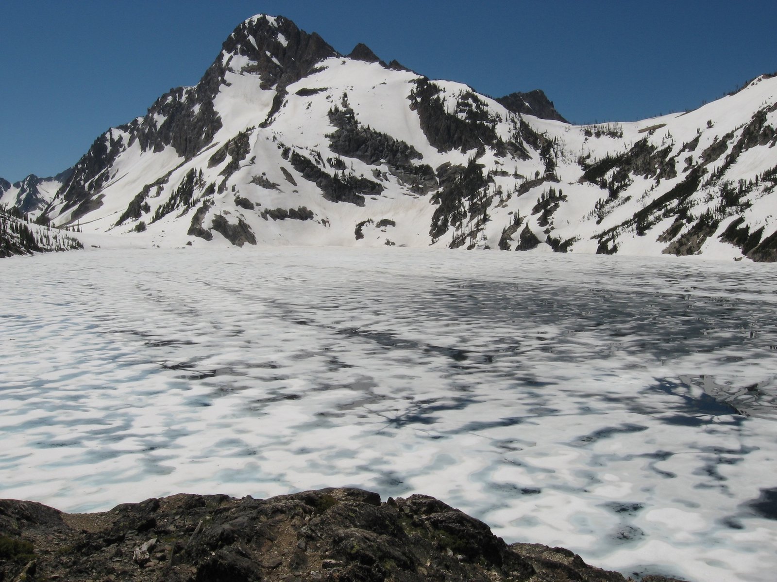
Sawtooth Lake is one of the most popular hikes in Idaho’s Sawtooth National Recreation Area, and it’s easy to see why. A 5-mile trail climbs from a forested creek bottom past a smaller alpine lake to a big lake set below jagged granite, with Mount Regan rising at its far end.
It works as a long day hike, but spending the night lets you have the lake at dusk and dawn. The catch is popularity: campsites are limited and fill early in summer.
The hike
The Iron Creek Trailhead sits next to Iron Creek Campground. One guide puts it about 15 minutes from Stanley via Forest Road 619. The first mile is easy forest walking with Iron Creek alongside. One trip report says you reach the Sawtooth Wilderness boundary in about three-quarters of a mile, and that the trail to Goat Lake forks off sharply to the left at about a mile.
At 1.5 to 1.7 miles, depending on the source, a signed junction points straight ahead toward Stanley Lake. The Sawtooth Lake route turns left and starts to climb. Switchbacks carry you up with widening views, and the trail crosses Iron Creek at about 2.7 miles by one account and 3 miles by another.
The side trail to Alpine Lake comes somewhere between 3.4 and 4 miles, again depending on who measured it, and the lake is a short drop below the trail. Wikipedia puts Alpine Lake at 7,828 feet, with 9,861-foot Alpine Peak at its south end, and says it can stay frozen into early summer. Several guides describe campsites on both sides of the lake, and one says the best are about halfway around. One photographer calls it a fine destination in itself and notes that some hikers base camp here and day hike to Sawtooth Lake.
Above the Alpine Lake junction the trail keeps climbing. Discover Sawtooth, the Sawtooth Interpretive & Historical Association’s site, says it gains about another 500 feet. Then the grade eases through a subalpine landscape of small streams and ponds. From there, the same photographer says, Sawtooth Lake is less than half a mile away.
Sawtooth Lake is the payoff. Wikipedia gives its surface elevation as 8,435 feet, says it often stays frozen into early summer, and puts 10,190-foot Mount Regan at its southern end. Discover Sawtooth calls it the biggest alpine lake in the Sawtooths. Published round-trip figures run from about 9.6 to 10 miles, with roughly 1,700 to 1,900 feet of gain.
The trail doesn’t end at the lake. Wikipedia says Sawtooth Lake often serves as a camp for longer hikes deeper into the northern Sawtooth Wilderness. One long-distance trip report describes camping at the north end of the lake, where the trail to the McGown Lakes branches off, before continuing south across the range. One guide suggests continuing past the outlet as an option for backpackers who want to extend the trip to other lakes.
This is one of the most visited trails in the area. A photographer who has backpacked here warns that nearly all backcountry camps in the Sawtooths fill up quickly, and that in the height of summer just about every campsite is taken before noon. Start early, especially on weekends.
For a longer Sawtooth trip that circles several lakes, see the Alice–Toxaway Loop.
Tips
- Get your permit at the trailhead. A free, self-issued wilderness permit is required for everyone entering the Sawtooth Wilderness, including day hikers. Discover Sawtooth says to fill it out completely, keep the tan copy, and drop the white copy in the box.
- Leave the campfire plans at home. A Forest Service order prohibits campfires within 200 yards of Sawtooth Lake and Alpine Lake and within a quarter mile of any Forest Service trail. Discover Sawtooth adds that rock fire rings are never allowed in the Sawtooth Wilderness. Bring a stove.
- Leash your dog in summer. From July 1 through Labor Day, the Forest Service order requires dogs on trails to be on a leash no longer than 15 feet.
- Expect snow and ice early. Wikipedia says both lakes can stay frozen into early summer. One guide suggests microspikes if there’s snow on the trail.
- Arrive early. The trailhead is popular, and Discover Sawtooth warns that trailhead parking lots are often small. Have a backup plan.
- Check fire restrictions. In September 2026, the Sawtooth National Forest alerts page listed Stage 1 fire restrictions. Check the current status before you go.
Camping
Camping is dispersed within the Sawtooth Wilderness, and your self-issued permit covers it. Discover Sawtooth says to camp at least 100 feet from water and trails, use existing impacted sites at popular lakes, and stay out of meadows. The Forest Service order limits groups to 12 people from May 1 through Nov. 30. Discover Sawtooth says groups of eight or more need a group permit from a Forest Service office or partner. The order also bans depositing human waste within 100 feet of springs, lakes, streams, or campsites. Discover Sawtooth says campsites at Sawtooth Lake are limited.
The Forest Service’s food storage order for the Sawtooth National Recreation Area does not apply inside the wilderness. Discover Sawtooth still strongly recommends a bear hang, bear canister, or bear-proof bag for food, trash, and toiletries.
Inside Intel: Campers describe a couple of sites right at the outlet of Sawtooth Lake near a big log jam. One guide says you can camp there, cross the jam and look for spots along the shore, or keep going to lakes farther in. One writer found a private site up on a ledge above the lake. If you arrive late, a photographer who has camped here suggests grabbing any open site in the pond area just before the lake rather than gambling on the shore. And if Sawtooth Lake is full, Alpine Lake is the fallback. One guide calls it camp-able with less hiker traffic, and another thought its view was actually better.
Trail facts
- Distance: About 9.6 to 10 miles round trip (about 4.5 to 5 miles one way)
- Route type: Out and back
- Difficulty: Moderate to strenuous. Sources range from “moderate to hard” to “challenging.”
- Elevation: About 1,700 to 1,900 feet of gain. Sawtooth Lake: 8,435 feet (Wikipedia).
- Campsites: Dispersed. Limited sites at Sawtooth Lake; more at Alpine Lake about a mile earlier.
- Water: Iron Creek, streams, and lakes along the route. Treat all water.
- Permits: Free self-issued Sawtooth Wilderness permit at the trailhead or wilderness boundary. Groups of 8 or more need a group permit.
- Fires: Not allowed within 200 yards of Sawtooth Lake or Alpine Lake, or within a quarter mile of trails (Forest Service order). Check for seasonal fire restrictions.
- Bear and food storage: Not required by order inside the wilderness, but a bear hang, canister, or bear-proof bag is strongly recommended.
- Dogs: Allowed; on a leash of 15 feet or less on trails from July 1 through Labor Day.
- Trailhead: Iron Creek Trailhead, Forest Road 619 off Idaho Highway 21, near Stanley
- Last verified: September 28, 2026
Where this comes from
This page draws on the sources below, along with other guides and trip reports. Links go to the original pages.
- U.S. Forest Service: Sawtooth Wilderness Area Occupancy and Use order
- U.S. Forest Service: Sawtooth National Forest permits
- Discover Sawtooth: Sawtooth Lake
- Discover Sawtooth: Leave No Trace in the Sawtooths
- Wikipedia: Sawtooth Lake
- Wikipedia: Alpine Lake (Northern Sawtooth Wilderness)
- Bearfoot Theory: Hiking to Sawtooth Lake
- Alan Majchrowicz: Sawtooth Lake Idaho
- U.S. Forest Service: Sawtooth National Recreation Area food storage order
Before you go: This page is based on published trail guides, trip reports, and reviews, along with official park and agency information where we could find it. It’s meant to help backpackers discover new trails, not to replace current, official information. Conditions, closures, permits, campsites, and water sources change, and some details here may be out of date or wrong. Confirm everything with the managing agency and check current conditions before you head out, and don’t rely on this page alone for safety or navigation. Backcountry travel involves risk.