
Trails / Idaho / Sawtooth Mountains
Vernon and Ardeth Lakes from Pettit Lake
Sawtooth Wilderness, Sawtooth National Recreation Area (Tin Cup Trailhead at Pettit Lake)
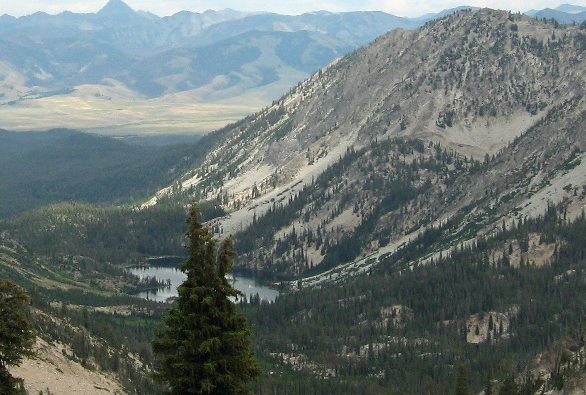
Ardeth Lake sits in a deep granite basin in the interior of the Sawtooth Wilderness. Outdoor Project calls it one of the most remote spots in the range. From the Tin Cup Trailhead at Pettit Lake, the route below follows the start of the Alice–Toxaway Loop, branches off past Edith Lake, crosses a pass to the Edna and Vernon Lakes, and reaches Ardeth on day two. The way out climbs over another pass to Toxaway Lake.
It’s a big trip, around 25 miles over three days, but it takes you well past the busier lakes near the trailhead.
The hike
The route starts at the Tin Cup Trailhead at Pettit Lake, the same trailhead as the Alice–Toxaway Loop. One Backcountry Post trip report describes reaching Farley Lake at about three miles, a good spot for a break. There, the writer left the Alice–Toxaway route and headed up toward Edith Lake. The writer says the White Clouds come into view from the turnoff and describes Edith Lake’s water as crystal clear.
Above Edith Lake, a sign put Edna Lake 3.5 miles ahead. The trail climbs to a pass with views back to Farley and Yellow Belly Lakes, then descends past Rendezvous Lake. The trip reached Edna Lake late on day one. The writer found it busy and kept going about five minutes to Vernon Lake, where they found a great campsite away from the crowd. The first day totaled about 10.1 miles.
The next morning was a short two-mile hike to Ardeth Lake. Outdoor Project describes Ardeth as filling a deep granite basin, with a triple buttress rising directly above the south shore and a steep, blunt granite ridge on the northeast side. It says the lake is smaller than Sawtooth Lake in the Iron Creek drainage but has a similar feel, probably because of its size and even shoreline. The trip report’s final morning brought a great view of Glens Peak over the lake.
Outdoor Project notes several side trips from here. Glens Peak can be climbed by several Class 2–3 routes and linked into a traverse from the Ardeth–Vernon saddle to Spangle Divide. The upper Middle Fork trail connects over Spangle Divide to Ardeth Lake. Outdoor Project’s approach from the Grandjean trailhead is 17 miles, but the Forest Service closed that trailhead on July 23, 2026, after debris flows.
A runner on the Idaho Wilderness Trail, writing for the Idaho Conservation League, describes the country north of Ardeth. After skirting Ardeth, the trail makes a short, steep climb to a small unnamed lake, then descends past Vernon and Edna Lakes before climbing past Hidden Lake to the Cramer Divide. The runner calls Cramer Divide the high point of the Sawtooth Wilderness section and one of the most dramatic views in the range. The runner also saw several hikers around Ardeth and fewer beyond it.
For the way out, the Backcountry Post writers filled up on water and climbed over a pass to Toxaway Lake. They didn’t find a campsite they liked and ended up hiking all the way out that day, a tough 13 miles back to the trailhead. That makes the full trip roughly 25 miles. You could also return the way you came.
On that trip, camping pressure eased the farther in they went: crowds at Edna Lake, plenty of room at Ardeth.
Tips
- Pick up your permit. A free, self-issued Sawtooth Wilderness permit is required. The permit box is near the wilderness boundary on the Pettit Lake side.
- No campfires on the Pettit and Yellow Belly Lake Creek side. A Forest Service order bans campfires in those drainages and within a quarter mile of any trail. Bring a stove.
- Stock restrictions at Edith Lake. The order prohibits overnight horses, mules, and goats within 200 yards of Edith Lake.
- Plan three days. The trip report’s days ran about 10, 2, and 13 miles; a shorter last day means camping at Toxaway, where the same writers couldn’t find a site they liked.
- Carry a good map. Several trails and passes meet in this area. Know which junctions you need.
- Grandjean is closed. Don’t plan an exit through Grandjean until the Forest Service reopens it.
Camping
Camping is dispersed in the Sawtooth Wilderness, and your self-issued permit covers it. Discover Sawtooth says to camp at least 100 feet from water and trails, use existing impacted sites where they exist, and avoid meadows. The Forest Service order limits groups to 12 people from May through November and requires dogs to be on a short leash on trails in midsummer. For food, Discover Sawtooth recommends a bear hang, canister, or bear-proof bag; the recreation area’s food storage order doesn’t apply inside the wilderness.
Outside the wilderness, at the trailhead end, a Forest Service order in effect since June 19, 2026 (0414-04-162) prohibits camping anywhere other than a developed campground between Forest Roads 208 or 362 and Pettit Lake. If you want to camp near the trailhead the night before, use a developed campground.
Inside Intel: If Edna Lake is crowded, keep walking. The Backcountry Post writers found no good spot at Edna, but just five minutes farther at Vernon Lake found a great campsite without the people. At Ardeth, the lake is big and has plenty of campsites around it, so there’s no need to crowd other groups. The same writers had another party start setting up just 15 yards away and asked them to move on. Give other campers room.
Trail facts
- Distance: About 25 miles as a loop out via Toxaway Lake (about 12 miles one way to Ardeth)
- Route type: Loop via Toxaway Lake, or out and back. Usually three days or more.
- Difficulty: Strenuous
- Campsites: Dispersed. Vernon, Edna, and Ardeth Lakes; Edith and Toxaway Lakes nearer the trailhead.
- Water: Lakes and creeks. Treat all water.
- Permits: Free self-issued Sawtooth Wilderness permit
- Fires: None in the Pettit and Yellow Belly Lake Creek drainages or within a quarter mile of trails (Forest Service order)
- Bear and food storage: Bear hang, canister, or bear-proof bag recommended
- Trailhead: Tin Cup Trailhead, Pettit Lake Campground, south of Stanley
- Last verified: October 17, 2026
Where this comes from
This page draws on the sources below, along with other guides and trip reports. Links go to the original pages.
- U.S. Forest Service: Sawtooth Wilderness Area Occupancy and Use order
- U.S. Forest Service: Grandjean Area, Road, and Trail Closure
- Outdoor Project: South Fork of the Payette overview (Ardeth Lake)
- Outdoor Project: Spangle Lake and Middle Fork Boise
- Backcountry Post: Sawtooths, Vernon, Ardeth, and Spangle Lakes
- Idaho Conservation League: Enduring the Idaho Wilderness Trail
- Discover Sawtooth: Leave No Trace in the Sawtooths
- U.S. Forest Service: Sawtooth National Recreation Area Occupancy and Use order 0414-04-162
Before you go: This page is based on published trail guides, trip reports, and reviews, along with official park and agency information where we could find it. It’s meant to help backpackers discover new trails, not to replace current, official information. Conditions, closures, permits, campsites, and water sources change, and some details here may be out of date or wrong. Confirm everything with the managing agency and check current conditions before you head out, and don’t rely on this page alone for safety or navigation. Backcountry travel involves risk.