
Trails / California / Southern California
San Gorgonio via the Vivian Creek Trail
San Gorgonio Wilderness, San Bernardino National Forest and Sand to Snow National Monument (Forest Falls)
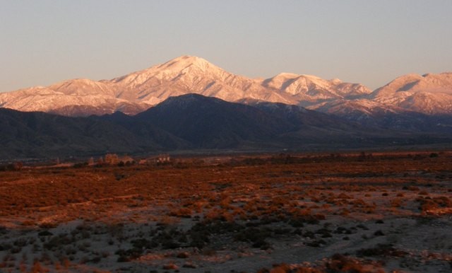
San Gorgonio is the highest peak in Southern California, at about 11,500 feet. The Vivian Creek Trail is its shortest and steepest route, climbing more than a vertical mile in about 8 miles from Forest Falls, past a series of designated camps, to the bare summit. Backpacking it lets you split the climb and, with the right permit, spend the night on top.
Permits are free but required, and you can camp only at designated sites.
The hike
The trailhead is reached by turning east off Highway 38 to Forest Falls, according to the San Gorgonio Wilderness Association. Hiking Guy describes crossing the usually dry Mill Creek wash, then a steep climb of about a mile to the wilderness boundary, where a sign marks the start of the permit area. The trail then levels out along Vivian Creek.
The SGWA lays out the camps. Vivian Creek Camp, at 7,100 feet, is 1.2 miles from the trailhead, with campsites upslope to the right of the trail after you reach the stream. Halfway Camp, at 8,100 feet, is 1.3 miles farther; water comes from the creek 200 yards before camp. High Creek Camp, at 9,200 feet, is 2.3 miles beyond that, with water. The summit is 3 miles past High Creek. Summit Camp sits just east of the true peak.
Halfway Camp’s name is misleading. A Gaia GPS commenter calls it really a third of the way to the summit, and Meg Hikes says it’s definitely not halfway up the trail. Several reviewers say there’s no water at Halfway itself, so fill up at Vivian Creek or the creek before camp.
High Creek is the key water stop. Meg Hikes calls it the last water source on the trail. A Dyrt reviewer calls the sound of High Creek running alongside camp the site’s defining feature. A Gaia GPS commenter notes that High Creek Camp has only three or four spots and was full on a Saturday.
Above High Creek, Hiking Project says the upper trail offers outstanding views of Yucaipa Ridge and Galena Peak, and sweeping views from the top. A Backpacking Light writer who camped on the summit in late October found it cold enough to freeze water bottles, and slept in one of the circular stone windbreaks common on the summit.
The SGWA describes the wilderness as about 95,000 acres, established in 1964 and managed jointly by the Forest Service and the Bureau of Land Management. It lists Barton Flats, San Gorgonio, South Fork, and Heart Bar as the closest developed campgrounds, all closed in winter.
The rules are strict. The Forest Service says no campfires are allowed at any time; gas stoves are allowed with a free California Campfire Permit. Groups are limited to 12 people. The SGWA FAQ says your wilderness permit covers your stove and no separate stove permit is needed. The SGWA also warns that years of fires have left many burned trees that are falling, so be prepared to hike around them.
Hiking Guy notes that your permit only allows camping in designated campsites, even though you’ll see some dispersed tent sites along the route.
For another Southern California summit trip, see San Jacinto via Round Valley.
Tips
- Request your permit early. The SGWA accepts applications up to 90 days ahead; the trail is very popular on summer weekends.
- Camp only at designated sites. Your permit won’t cover the dispersed spots you see along the way.
- Fill water at High Creek. It’s described as the last reliable source before the summit.
- No campfires. Stoves only.
- Watch for falling trees. The SGWA warns of fire-damaged trees along trails.
Camping
A free wilderness permit from the San Gorgonio Wilderness Association is required for overnight trips, and camping is allowed only in designated camps. The SGWA says no camping within 200 feet of the trail or creek at Vivian Creek Camp. The Forest Service limits groups to 12 people and bans campfires; gas stoves are allowed.
Inside Intel: Halfway Camp is the easier permit to get. A Dyrt reviewer says High Creek is always the most popular, and they’ve never had trouble getting a permit for Halfway. Meg Hikes recommends Halfway for larger groups. If you can land a High Creek permit, a Gaia GPS commenter notes it has only a few spots, but it puts you closest to the summit with water.
Trail facts
- Distance: About 16.2 miles round trip to the summit
- Route type: Out and back
- Difficulty: Very strenuous. More than a vertical mile of climbing.
- Elevation: Vivian Creek Camp 7,100 feet; Halfway 8,100; High Creek 9,200; summit about 11,500
- Campsites: Vivian Creek, Halfway, High Creek, and Summit Camps (designated)
- Water: Vivian Creek and High Creek; none at the summit. Treat all water.
- Permits: Free wilderness permit required (SGWA)
- Fires: None allowed; gas stoves only
- Group size: 12 maximum
- Trailhead: Vivian Creek Trailhead, Forest Falls (off Highway 38)
- Last verified: October 2, 2026
Where this comes from
This page draws on the sources below, along with other guides and trip reports. Links go to the original pages.
- U.S. Forest Service: San Gorgonio Wilderness
- San Gorgonio Wilderness Association: Trails
- San Gorgonio Wilderness Association: Permits
- San Gorgonio Wilderness Association: FAQs
- Hiking Project: Vivian Creek Trail
- Hiking Guy: San Gorgonio Hike
- Meg Hikes: Backpacking San Gorgonio via Vivian Creek
- Gaia GPS: San Gorgonio via Vivian Creek
Before you go: This page is based on published trail guides, trip reports, and reviews, along with official park and agency information where we could find it. It’s meant to help backpackers discover new trails, not to replace current, official information. Conditions, closures, permits, campsites, and water sources change, and some details here may be out of date or wrong. Confirm everything with the managing agency and check current conditions before you head out, and don’t rely on this page alone for safety or navigation. Backcountry travel involves risk.