
Trails / California / Sierra Nevada
Echo Lakes to Lake Aloha (Desolation Wilderness)
Desolation Wilderness, Eldorado National Forest and Lake Tahoe Basin Management Unit (Echo Summit, near South Lake Tahoe)
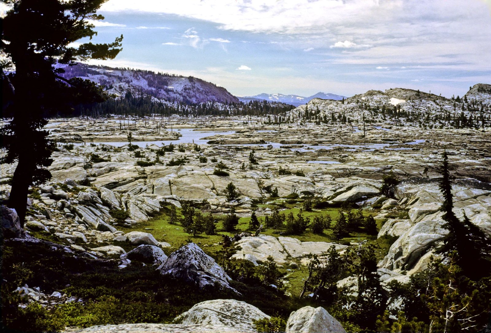
Lake Aloha is a large lake scattered with granite islands near the Crystal Range in the Desolation Wilderness, west of Lake Tahoe. Cal Explornia calls it one of the best-known destinations from the Echo Lakes Trailhead, about 6 miles in on the Pacific Crest Trail. The route follows the shore of the Echo Lakes before climbing into the wilderness.
The Desolation Wilderness is one of the most heavily used wilderness areas in the country, so permits and rules are strict here.
The hike
The Forest Service says the Echo Lakes Trailhead sits on Echo Summit near the south shore of Lake Tahoe and serves as a trailhead into the Desolation Wilderness. It warns the area can be extremely crowded on weekends and suggests visiting early or late in the day. The trailhead is day use only, with no camping or overnighting allowed there. Cal Explornia notes that parking fills early and that the final road to the trailhead is seasonal.
From the trailhead, the Pacific Crest Trail follows the shore of the Echo Lakes. Recreation.gov says the PCT traverses 17 miles through the Desolation Wilderness, from Echo Lakes north to Richardson Lake. Cal Explornia says you’ll need to decide whether to hike along the lakes or take the seasonal Echo Chalet boat taxi. The Dyrt says the taxi cuts about 2.5 miles off the hike each way.
You don’t need a permit just to visit Echo Chalet or walk up to the wilderness boundary, according to Cal Explornia. Once inside the Desolation Wilderness, a free day-use permit or a paid overnight permit is required year-round. The Forest Service explains why: because of its beauty and accessibility, Desolation is one of the most heavily used wilderness areas in the United States, so access is limited and certain activities are restricted.
Past the Echo Lakes, the trail climbs into the wilderness. Discover Echo Summit’s zone table lists the lakes of the Aloha zone: Lake Aloha’s east shore, Heather Lake, Lake LeConte, Jabu Lake, Lake Lucille, and Lake Margery. It lists Lake Aloha’s west shore in the Price zone, along with Pyramid Peak and the Crystal Range. Cal Explornia describes Lake Aloha’s granite islands, irregular shoreline, and location deep in the wilderness.
The permit system is different here. High Sierra Trails explains that Desolation quotas are based on the zone where you camp your first night, not the trailhead. It says most people heading to Lake Aloha camp in Zone 33, but other zones border the lake and offer alternatives if your first choice is full. The Forest Service says quotas apply from the Friday before Memorial Day through September 30.
The Forest Service also lists a rule worth checking before you go. In its section on Tahoe Rim Trail thru-hike permits, it says camping along or around Lake Aloha is prohibited. It isn’t clear from that page whether this applies to all visitors, so confirm with the Forest Service when you get your permit.
Recreation.gov says the Desolation Valley Primitive Area was established in 1931 and became a congressionally designated wilderness in 1969.
For another Sierra lake trip, see Thousand Island Lake.
Tips
- Get the right zone. Desolation permits are by first-night zone, not trailhead.
- Carry a bear canister. The Forest Service requires hard-sided canisters for all overnight visitors.
- No campfires. Campfires are prohibited throughout the Desolation Wilderness; your wilderness permit serves as your campfire permit for a gas stove.
- Arrive early. The Forest Service says the trailhead can be extremely crowded on weekends.
- Ask about Lake Aloha camping. Confirm whether lakeshore camping is allowed when you get your permit.
Camping
An overnight wilderness permit is required year-round, reserved through Recreation.gov. The Forest Service says 70 percent of the daily quota is reservable from six months to one day ahead during the quota season, and that from October 1 to Memorial Day weekend, you still need a zone but groups can include up to 12 overnight users. Bear canisters are required, and campfires are prohibited. The Dyrt adds that campers should stay at least 100 feet from water.
Inside Intel: High Sierra Trails says most people heading to Lake Aloha camp in Zone 33, and points out that several other zones also border the lake, which helps if Zone 33 is full. Discover Echo Summit’s zone table is the best place to see which lakes fall in which zone before you book. Given the Forest Service’s note about camping around Lake Aloha, a nearby lake in the same zone, such as Heather or Lake Lucille, may be the safer plan.
Trail facts
- Distance: About 12.2 miles round trip from Echo Chalet (about 7 with the boat taxi both ways)
- Route type: Out and back
- Difficulty: Moderate
- Campsites: Wilderness camping by zone; confirm Lake Aloha lakeshore rules
- Water: Lakes along the route. Treat all water.
- Permits: Required year-round for day and overnight use; overnight quotas from the Friday before Memorial Day through September 30
- Bear and food storage: Hard-sided bear canister required
- Fires: Prohibited throughout the wilderness
- Trailhead: Echo Lakes Trailhead, Echo Summit (day use only; no overnight camping at the trailhead)
- Last verified: October 2, 2026
Where this comes from
This page draws on the sources below, along with other guides and trip reports. Links go to the original pages.
- U.S. Forest Service: Desolation Wilderness
- U.S. Forest Service: Desolation Wilderness Permits
- U.S. Forest Service: Echo Lakes Trailhead - PCT Access
- Recreation.gov: Desolation Wilderness Permit
- High Sierra Trails: Lake Aloha permits
- Discover Echo Summit: Desolation Wilderness permits
- Cal Explornia: Echo Lakes Trailhead
Before you go: This page is based on published trail guides, trip reports, and reviews, along with official park and agency information where we could find it. It’s meant to help backpackers discover new trails, not to replace current, official information. Conditions, closures, permits, campsites, and water sources change, and some details here may be out of date or wrong. Confirm everything with the managing agency and check current conditions before you head out, and don’t rely on this page alone for safety or navigation. Backcountry travel involves risk.