
Trails / California / Northern California
Canyon Creek Lakes (Trinity Alps Wilderness)
Trinity Alps Wilderness, Shasta-Trinity National Forest (Canyon Creek Road, north of Junction City)
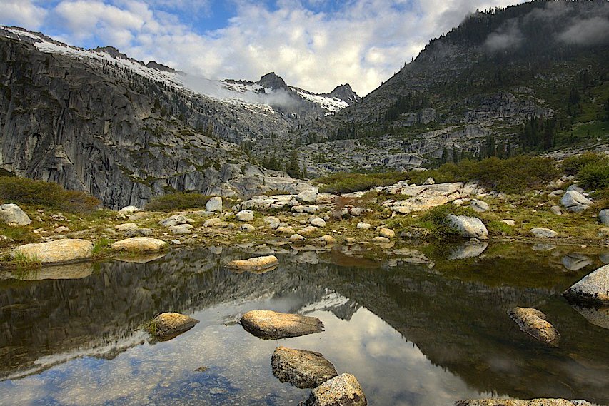
Canyon Creek Lakes sit at the head of a deep granite canyon in the Trinity Alps of Northern California, below Thompson Peak. SummitPost calls them the most popular destination in the Trinity Alps. The trail follows Canyon Creek for about 7.5 miles past three waterfalls and a string of meadows to the lower and upper lakes. Permits are free, self-issued, and have no quota.
The catch is the drive. One trip report says it took about six hours to reach the trailhead from the San Francisco Bay Area.
The hike
The trailhead is at the end of Canyon Creek Road. Indi Nomads gives the directions: from Weaverville, head west on Highway 299 for 8 miles to Junction City, turn onto Canyon Creek Road, and drive about 14 miles to the end. Miss Rover notes vault toilets at the trailhead. SummitPost says Canyon Creek cuts into the heart of the White Trinities and calls the hike to the lakes relatively easy for its length. It adds that the canyon itself begins at the confluence of Canyon and Bear Creeks, a short distance from the trailhead.
Hike Mt. Shasta describes the route: the trail heads north along the east side of Canyon Creek, crosses Bear Creek soon after the start, and at about 2.5 miles passes a short spur to McKay Camp, a small island in the creek reached by a large log bridge. SummitPost calls McKay Camp the only good campsite in the lower canyon and says excellent sites appear consistently once you pass the Lower Falls.
Three waterfalls mark the climb. Indi Nomads puts Lower Canyon Creek Falls at about 4 miles, Middle Falls at about 4.5, and Upper Falls at about 6. Miss Rover gives somewhat longer mileages and calls them very short detours. Hike Mt. Shasta says that above the junction with the Boulder Creek Lakes trail, the trail continues another mile to a set of switchbacks, where Upper Canyon Creek Falls comes into view, followed by almost a mile of meadow.
Sunny With A Chance of Berries describes waterfalls cascading over smooth granite and good campsites along the creek on the way up. The same writers camped their first night at The Sinks, a network of small islands among braided creek channels about 3.5 miles in.
The trail ends at the lakes. AllTrails says the most picturesque campsites are around and just above the upper lakes and Upper Canyon Creek Falls. Indi Nomads notes that the trailhead sign says 8 miles to the lower lake. Thompson Peak rises above Upper Canyon Creek Lake, per Hike Mt. Shasta.
The area offers side trips. Miss Rover says Boulder Creek Lakes is another popular camping destination that sees fewer people than Canyon Creek Lakes. SummitPost says there are no good places to camp between the Canyon Creek ford and Boulder Creek Lakes, but several spots around those lakes. AllTrails lists a longer route that adds L Lake.
The trail is busy in summer. Somewhere Sierra describes lots of foot traffic, and one August 2026 reviewer saw no one for the first 3 to 4 miles and still got the best campsite at the upper lake.
For another Western wilderness lake trip, see Thousand Island Lake.
Tips
- Get your permit on the way. Permits are free and self-issued at the trailhead or the Weaverville Ranger Station. Miss Rover says the trailhead box isn’t always stocked.
- Get a California Campfire Permit. Sources say it’s required even for camp stoves.
- Bring a bear canister. It’s strongly recommended, per one permit guide.
- Arrive early on summer weekends. One guide warns of a full trailhead.
- Check fire restrictions. Confirm current restrictions with the Shasta-Trinity National Forest before you go.
Camping
Camping is dispersed in the Trinity Alps Wilderness with a free, self-issued wilderness permit and no quota. A California Campfire Permit is required for stoves and fires. SummitPost says there are numerous campsites along Canyon Creek. Ripstein Campground, a first-come, first-served campground a few miles from the trailhead, is an option for the night before, per Somewhere Sierra.
Inside Intel: The upper lake has the most sought-after sites. An August 2026 AllTrails reviewer grabbed what they called the “it” campsite there. Hike Mt. Shasta points to an excellent site on an island at the base of Upper Canyon Creek Falls. For a short first night, Sunny With A Chance of Berries camped at The Sinks, about 3.5 miles in, and SummitPost calls McKay Camp the only good site in the lower canyon.
Trail facts
- Distance: About 15 to 16 miles round trip to the lakes (15.6 per AllTrails)
- Route type: Out and back
- Difficulty: Strenuous. About 2,800 to 3,200 feet of gain.
- Campsites: Dispersed; McKay Camp, The Sinks, near the falls, and around the lakes
- Water: Canyon Creek and the lakes. Treat all water.
- Permits: Free, self-issued wilderness permit (no quota); California Campfire Permit for stoves
- Bear and food storage: Canister strongly recommended
- Trailhead: Canyon Creek Trailhead, end of Canyon Creek Road, north of Junction City
- Season: May through October (AllTrails)
- Last verified: October 2, 2026
Where this comes from
This page draws on the sources below, along with other guides and trip reports. Links go to the original pages.
- Outdoor Status: Canyon Creek Lakes
- SummitPost: Canyon Creek
- Hike Mt. Shasta: Canyon Creek Trail
- AllTrails: Canyon Creek Lakes Trail
- Somewhere Sierra: Backpacking the Canyon Creek Lakes Trail
- Sunny With A Chance of Berries: Canyon Creek Lakes
- Trek Bound: Trinity Alps Wilderness Permit Guide
- Miss Rover: Canyon Creek Lakes Trail
Before you go: This page is based on published trail guides, trip reports, and reviews, along with official park and agency information where we could find it. It’s meant to help backpackers discover new trails, not to replace current, official information. Conditions, closures, permits, campsites, and water sources change, and some details here may be out of date or wrong. Confirm everything with the managing agency and check current conditions before you head out, and don’t rely on this page alone for safety or navigation. Backcountry travel involves risk.