
Trails / California / Sierra Nevada
Big Pine Lakes via the North Fork of Big Pine Creek
John Muir Wilderness, Inyo National Forest (Glacier Lodge Road, west of Big Pine)
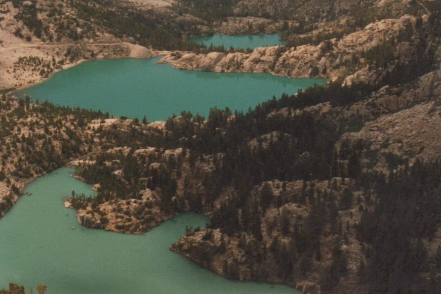
The Big Pine Lakes are a chain of turquoise alpine lakes fed by the Palisade Glacier, according to a local lodge’s trail guide, on the east side of the Sierra. The North Fork of Big Pine Creek trail climbs past waterfalls and a historic cabin built by silent-film actor Lon Chaney to First, Second, and Third Lakes. The trail continues to more lakes and the Palisade Glacier for those with extra days.
Permits are limited, and the climb is steep and exposed in places.
The hike
The trailhead is at the end of Glacier Lodge Road, which the Palisades Lodge of Big Pine puts 10.7 miles west of the town of Big Pine. The Adventure Out There says the trailhead is clearly marked for hikers and overnight parking, and that you don’t need a parking permit. Follow Tiff’s Journey notes bear lockers and restrooms at both trailheads and warns that bears are around, including in the parking lot.
The trail starts with a climb. The Out and Backpack trip report describes a shaded stretch early on before an exposed uphill climb to Second Falls, passing First Falls on the North Fork along the way. Another guide puts the John Muir Wilderness boundary and Second Falls around the 2-mile mark. After that, The Adventure Out There says, the trail passes through wooded forest of aspens and pines that offers some relief from the sun.
Lon Chaney’s cabin comes next. Our Infinite Earth puts it at about 2.75 miles and 9,150 feet. The Palisades Lodge guide says Chaney built it in 1929 as a private retreat, and it’s now a Forest Service historic site. California Through My Lens notes that you can’t go inside but that it’s an impressive spot to see.
The Palisades Lodge guide calls the cabin the natural rest stop and water break, and estimates 3.5 to 4.5 hours of hiking to reach First Lake. From the cabin, the trail climbs gradually to First Lake. The Last Adventurer puts First Lake at 9,960 feet, about four and a half miles from the trailhead. The Adventure Out There describes a sign stating “no fires” at the 10,000-foot mark. California Through My Lens describes the trail running above First Lake to a rocky overlook.
Second and Third Lakes follow quickly. Our Infinite Earth puts Second Lake at about 4.8 miles and 10,050 feet. The Last Adventurer says Third Lake, the shallowest of the three, is at 10,249 feet, about 6.5 miles from the trailhead. It also mentions a spur trail between First and Second Lakes where old mining equipment and the remains of a dam can be found.
The lakes go on. Our Infinite Earth says there are seven officially named Big Pine Lakes, First through Seventh, plus two more reachable by the North Fork trail. California Through My Lens puts the Palisade Glacier about 7 more miles beyond Second and Third Lakes. The Last Adventurer notes that the lakes and waterfalls were given generic names for unknown reasons.
CALWILD says the trail lies within the ancestral homelands of the Eastern Mono and Northern Paiute peoples.
For another Eastern Sierra trip, see Little Lakes Valley.
Tips
- Reserve your permit early. Out and Backpack calls this one of the most popular hikes in the Inyo National Forest.
- Bring a bear canister. Most sources say it’s required for overnight stays; confirm with the Forest Service.
- No campfires. High Sierra Trails says they’re not permitted at Big Pine Lakes.
- Use the trailhead bear lockers. Store anything scented you leave in the car.
- Expect snow early in the season. Out and Backpack notes snow on the trail until late May or early June.
Camping
A wilderness permit is required for overnight trips, with a daily quota of 25 overnight hikers from May 1 to November 1, according to High Sierra Trails, CALWILD, and the Palisades Lodge. Our Infinite Earth says to camp at least 100 feet from water and trails. The Inyo National Forest limits groups to 15 and requires bear containers where trees aren’t adequate to hang food. High Sierra Trails says campfires aren’t allowed at Big Pine Lakes.
Inside Intel: Third Lake is the camper’s tip. The Last Adventurer says its campsites receive substantially less use than those at Second Lake. Our Infinite Earth lists Second Lake, Third Lake, Summit Lake, and Sixth Lake as the best lakes for camping and saw no one camping past Third Lake. The Adventure Out There found illegal fire rings at a few sites and asks backpackers to dismantle them.
Trail facts
- Distance: About 13 to 14.5 miles round trip to Second and Third Lakes
- Route type: Out and back
- Difficulty: Strenuous. About 2,000 to 2,300 feet of gain to Second Lake.
- Elevation: First Lake about 9,950 feet; Third Lake 10,249 feet
- Campsites: Dispersed at the lakes; Third Lake reportedly less used
- Water: Creek and lakes. Treat all water.
- Permits: Required for overnight trips; quota of 25 per day May 1 to November 1
- Bear and food storage: Canister required or strongly recommended (sources differ); confirm
- Fires: Not permitted at the lakes
- Trailhead: Big Pine Creek North Fork, end of Glacier Lodge Road, 10.7 miles west of Big Pine
- Last verified: October 2, 2026
Where this comes from
This page draws on the sources below, along with other guides and trip reports. Links go to the original pages.
- U.S. Forest Service: Inyo National Forest Wilderness Regulations
- High Sierra Trails: Big Pine Lakes wilderness permits
- The Last Adventurer: North Fork Big Pine Creek to Third Lake
- Our Infinite Earth: Big Pine Lakes guide
- California Through My Lens: North Fork of Big Pine
- Out and Backpack: Backpacking Big Pine Lakes
- The Adventure Out There: Backpacking Big Pine Lakes
- When Shiz Hits the Van: Backpacking Big Pine Lakes
- Palisades Lodge of Big Pine: Big Pine Lakes Trail Guide
Before you go: This page is based on published trail guides, trip reports, and reviews, along with official park and agency information where we could find it. It’s meant to help backpackers discover new trails, not to replace current, official information. Conditions, closures, permits, campsites, and water sources change, and some details here may be out of date or wrong. Confirm everything with the managing agency and check current conditions before you head out, and don’t rely on this page alone for safety or navigation. Backcountry travel involves risk.