
Trails / Arizona / Central Arizona
Barnhardt and Y Bar Loop (Mazatzal Wilderness)
Mazatzal Wilderness, Tonto National Forest, Payson Ranger District (south of Payson)
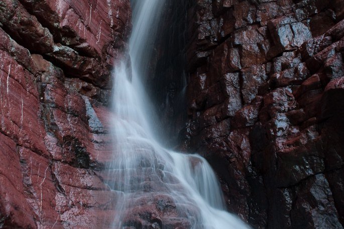
The Barnhardt and Y Bar Loop circles the high flanks of Mazatzal Peak, at 7,903 feet the highest point in the Mazatzal Wilderness. It climbs a dramatic canyon with a seasonal waterfall on the Barnhardt Trail, follows the Arizona Trail along the Mazatzal Divide, and returns on the rocky Y Bar Trail with big views. One Backpacking Light poster calls the Barnhardt Trail one of the top five classic hikes in Arizona outside the Grand Canyon.
It’s a hard 15 miles, and water is the constant question.
The hike
5enses magazine gives the directions: from Payson, go south on State Route 87 (the Beeline Highway) about 12 miles to Forest Road 419, then 5.1 miles to the trailhead. It says the Mazatzal Wilderness covers 205,500 acres, ranging from 2,100 feet to 7,903 feet at Mazatzal Peak, with 240 miles of trail. It says the Barnhardt Trail is managed by the Payson Ranger District. Aspen’s Tracks notes it was one of the original wilderness areas designated when the Wilderness Act passed in 1964.
The two trails leave the same trailhead. WildPathsAZ says you reach the Y Bar junction almost immediately. Going counterclockwise, you fork right to stay on the Barnhardt Trail. It describes the trail climbing the canyon toward the Mazatzal Divide, hugging the left side high above the drainage, with the sound of running water below in season. 5enses says the switchbacks begin at about 1.6 miles.
Barnhardt Falls is the first highlight. AllTrails describes a waterfall route of about 6.2 miles round trip and notes the falls may not be visible in the dry season. 5enses says the best time to go is after rain, when the waterfall is running, and suggests March or April because the lower trail can be too hot in summer and the higher parts too cold in winter. Aspen’s Tracks describes spectacular chevron folding exposed in Barnhardt Canyon.
Higher up, 5enses puts the Sandy Saddle Trail junction at about 5 miles and Barnhardt Saddle and the Mazatzal Divide at 6.2 miles. There you meet the Arizona Trail’s Mazatzal Divide passage. WildPathsAZ notes that Chilson Spring is about half a mile off the loop to the north if you need water. 5enses calls Chilson one of the few places along the trail that usually has water, and puts Windsor Spring Saddle at 8.5 miles.
The Y Bar Trail brings you home around the south and east sides of Mazatzal Peak. Wilderness Portal calls the climb up Y Bar a relentless ascent that locals nickname the Stairmaster, gaining about 2,350 feet in 5.6 miles from the trailhead to Windsor Saddle. It says water is seasonal and unreliable, limited to the Y Bar Tanks seep and pools in the basin. WildPathsAZ warns of a small clearing where the official trail seems to disappear and a tempting drainage that isn’t the trail.
AllTrails reviewers describe nonstop ups and downs, rocky slopes, and some great views near Mazatzal Peak. One, who did a two-night trip clockwise, found water at Windsor Spring and a full but cloudy catchment at Bear Spring, and abundant water along the Barnhardt Trail.
For another central Arizona overnight, see Reavis Ranch in the Superstition Wilderness.
Tips
- Go in spring after rain. 5enses suggests March or April, especially after rain when the waterfall runs.
- Carry more water than you think. A Backpacking Light poster says water is scarce, mostly seeps at best.
- Bring a GPS track. Parts of the Y Bar Trail are faint or easy to lose.
- Wear long pants. AllTrails notes the trail can be overgrown in summer.
- Watch the heat. Even in March, one hiker warns, heat can be trouble without plenty of water.
Camping
Camping is dispersed in the Mazatzal Wilderness. We didn’t find a permit requirement or a Forest Service page with specific rules for this loop. Contact the Payson Ranger District for current fire restrictions and conditions.
Inside Intel: Overnight accounts center on the upper loop near the Mazatzal Divide. One AllTrails reviewer on a two-night trip camped at Bear Spring, where the catchment was full but cloudy. WildPathsAZ’s advice is to fill up at the Barnhardt waterfall on the way up, since Chilson Spring means a half-mile detour off the loop. Plan your camp around whichever spring the most recent trip reports say is flowing.
Trail facts
- Distance: About 15 miles as a loop
- Route type: Loop, either direction
- Difficulty: Strenuous
- Elevation: About 3,000 to 3,250 feet of gain. Mazatzal Peak 7,903 feet (5enses).
- Campsites: Dispersed, mainly near springs on the upper loop
- Water: Seasonal and unreliable (Barnhardt Creek, Chilson Spring, Windsor Spring, Bear Spring). Treat all water.
- Permits: None found
- Trailhead: Barnhardt Trailhead, Forest Road 419 off State Route 87, south of Payson
- Season: Spring and fall
- Last verified: September 30, 2026
Where this comes from
This page draws on the sources below, along with other guides and trip reports. Links go to the original pages.
- 5enses: Barnhardt Trail and Falls
- WildPathsAZ: Barnhardt Y Bar Loop
- Wilderness Portal: Y Bar Basin Trail
- Aspen’s Tracks: Barnhardt Trail
- Jacob Emerick: Mazatzal Peak Loop
- Backpacking Light: Mazatzal Wilderness thread
- AllTrails: Y Bar and Barnhardt Loop
Before you go: This page is based on published trail guides, trip reports, and reviews, along with official park and agency information where we could find it. It’s meant to help backpackers discover new trails, not to replace current, official information. Conditions, closures, permits, campsites, and water sources change, and some details here may be out of date or wrong. Confirm everything with the managing agency and check current conditions before you head out, and don’t rely on this page alone for safety or navigation. Backcountry travel involves risk.