
Trails / Alaska / Southeast Alaska
Dan Moller Trail and Cabin
Tongass National Forest, Juneau Ranger District (Douglas Island, Juneau)
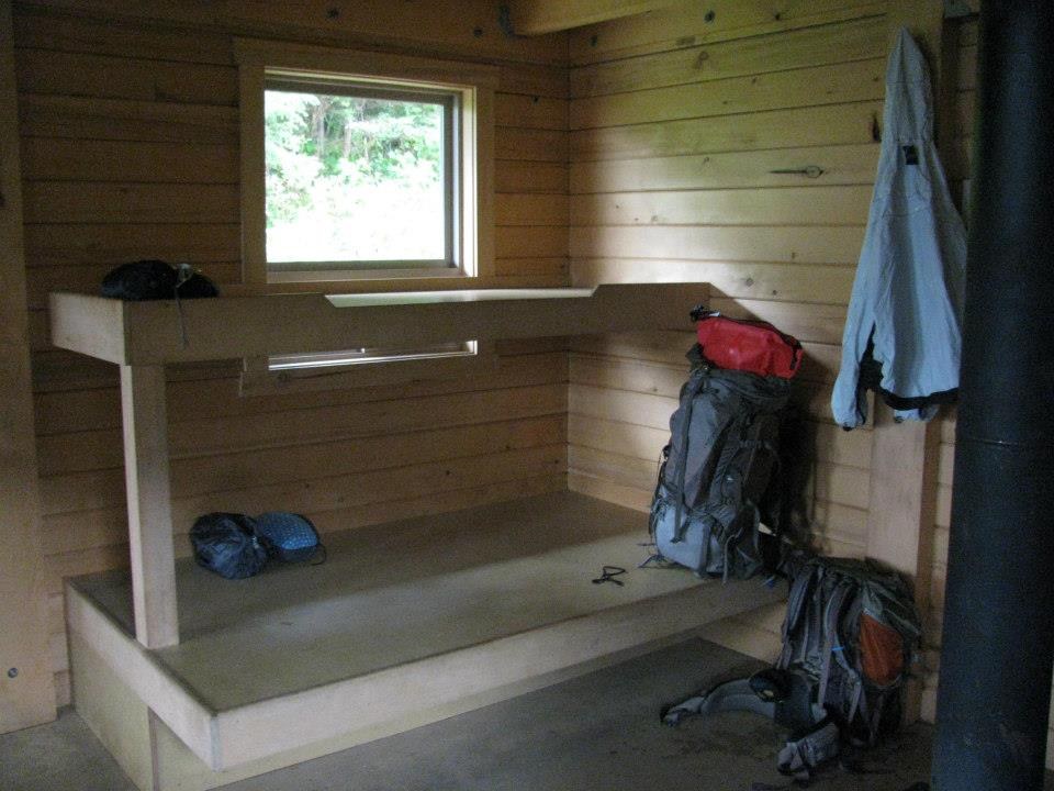
The Dan Moller Trail climbs from West Juneau up the Kowee Creek valley on Douglas Island to a historic log cabin in open alpine meadows. Recreation.gov says the cabin sits at 1,800 feet with views of snow-capped peaks, and one guide says the view from the cabin stretches over downtown Juneau, Stephens Passage, and Admiralty Island. It’s about 3 miles each way, mostly on boardwalk.
The cabin is reservable, and it’s open during the day as a public warming shelter.
The hike
Recreation.gov lists two trailheads: one on Pioneer Street off Cordova Street in West Juneau, and one at the end of Jackson Road. AllTrails says both start points on Douglas Island connect quickly on the Treadwell Ditch Trail, and Hiking Project describes the Dan Moller Trail as an offshoot of it.
From there, the trail heads uphill toward the mountains. Recreation.gov says the trail follows Kowee Creek and passes meadows that bloom with wildflowers in summer. It describes the trail as partially planked and passing through muskeg, with planks that are slippery when wet or frosty. Hiking Project calls it mostly boardwalk, with broken pieces and a few rocky spots. AllTrails reviewers agree the boardwalk gets weathered and is sometimes missing in places, and one warns it’s slippery on the way down. Komoot says you’ll pass streams and waterfalls through the temperate rainforest.
The cabin has a history. ALASKA.ORG says the Civilian Conservation Corps built it in the 1930s as part of a joint effort by the Juneau Ski Club and the Forest Service to develop winter recreation. The area was used for downhill skiing from 1939 to 1975, when Eaglecrest Ski Area opened just over the ridge. The cabin was restored in the winter of 1983-84. ALASKA.ORG describes it as a 16-by-20-foot log cabin for four to six people.
Recreation.gov says the trail continues past the cabin into the mountains overlooking Juneau and Admiralty Island. Hiking Project says the valley opens up beyond the cabin, with smaller alpine trails leading to the ridgeline.
The cabin is used year-round. Recreation.gov says it can be reached by hiking, snowshoeing, skiing, or snowmobile once snow is at least a foot deep. It stresses that the cabin is in an extremely remote and wild area and that visitors should learn about bear, water, and cold-weather safety before reserving. There’s no water at the cabin, and guests must bring their own or treat water from natural sources. Visitors are expected to pack out trash and clean the cabin before leaving.
Hiking Project lists the trail’s low point at about 715 feet and high point at about 1,816 feet, with an average grade near 9 percent. A third-party cabin listing says the cabin has a wood stove but no running water or electricity. Recreation.gov notes that commercial outfitters and guides can’t use the cabin, and that it can also be reached by helicopter.
AllTrails calls this a very popular area where you’ll likely meet other people, and lists May through October as the best months for hiking.
For another Southeast Alaska overnight, see the Deer Mountain Trail in Ketchikan.
Tips
- Reserve the cabin early. Reservations are through Recreation.gov. One listing notes a two-night maximum stay.
- Watch the boardwalk. Planks can be slippery when wet or frosty, and some are broken or missing.
- Bring water or a filter. Recreation.gov says there’s no water at the cabin.
- Expect daytime visitors. The cabin is open to the public as a warming shelter from 10 a.m. to 5 p.m.
- Prepare for bears and cold. Recreation.gov urges visitors to learn about bear, water, and weather safety before going.
Camping
The main overnight option is the reservable Forest Service cabin. Recreation.gov says visitors must bring several of their own amenities, including water, and pack out their trash. AllTrails notes opportunities for camping in the area, but we didn’t find a Forest Service rule on tent camping near the cabin. Confirm with the Juneau Ranger District at 8510 Mendenhall Loop Road before planning to camp without the cabin.
Inside Intel: Several sources point beyond the cabin. Hiking Project notes that the valley opens up above it, with smaller alpine trails to the ridgeline, and Recreation.gov says the trail continues into the mountains overlooking Juneau and Admiralty Island. With a cabin night, you can drop your pack and use the evening or next morning to explore that upper valley. Bring traction for the descent, since AllTrails reviewers single out the slippery boardwalk on the way down.
Trail facts
- Distance: About 6 miles round trip (sources range from 5.6 to 6.6)
- Route type: Out and back
- Difficulty: Moderate
- Elevation: About 1,300 to 1,800 feet of gain; cabin at about 1,800 feet (Recreation.gov)
- Campsites: Reservable Dan Moller Cabin; dispersed camping unconfirmed
- Water: None at the cabin. Treat water from natural sources.
- Permits: Cabin reservation through Recreation.gov
- Trailheads: Pioneer Street off Cordova Street, or the end of Jackson Road, West Juneau (Douglas Island)
- Season: Year-round; May through October for hiking (AllTrails)
- Last verified: September 28, 2026
Where this comes from
This page draws on the sources below, along with other guides and trip reports. Links go to the original pages.
- Recreation.gov: Dan Moller Cabin
- Recreation.gov: Dan Moller Cabin availability and details
- ALASKA.ORG: Dan Moller Cabin
- Hiking Project: Dan Moller Trail #518
- Komoot: Dan Moller Cabin Trail
- AllTrails: Dan Moller Cabin Trail
- Camp Scanner: Dan Moller Cabin
Before you go: This page is based on published trail guides, trip reports, and reviews, along with official park and agency information where we could find it. It’s meant to help backpackers discover new trails, not to replace current, official information. Conditions, closures, permits, campsites, and water sources change, and some details here may be out of date or wrong. Confirm everything with the managing agency and check current conditions before you head out, and don’t rely on this page alone for safety or navigation. Backcountry travel involves risk.