
Trails / Alabama / Central Alabama
Flagg Mountain and the Pinhoti's Southern End
Weogufka State Forest, Alabama Forestry Commission (Coosa County, near Weogufka)
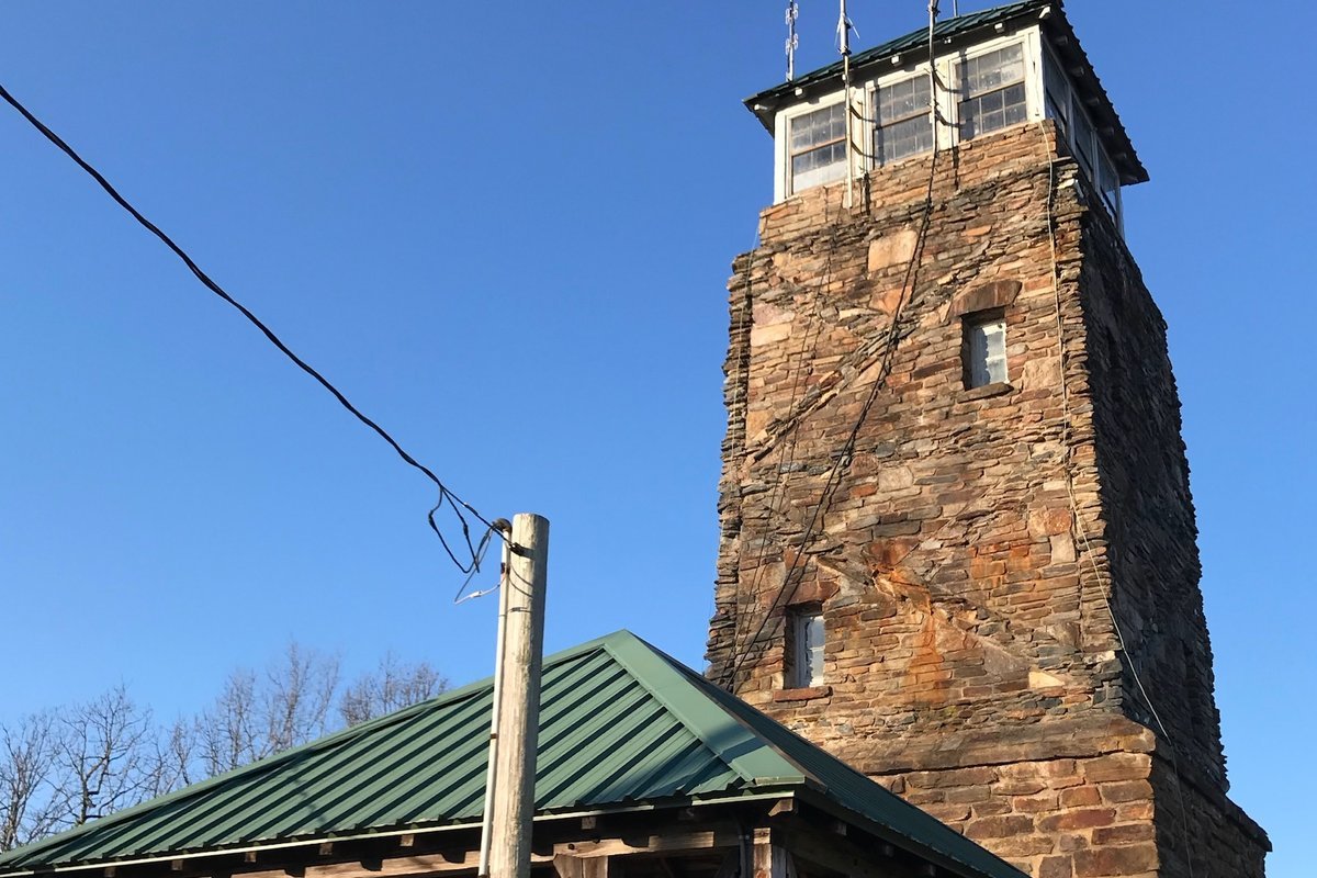
Flagg Mountain is where the Pinhoti Trail begins. The Alabama Forestry Commission calls it the southernmost Appalachian peak over 1,000 feet. Its summit holds a stone fire lookout built by the Civilian Conservation Corps in the 1930s, and from there the Pinhoti heads north for about 335 miles through Alabama and Georgia toward the Appalachian Trail.
An overnight here combines a historic mountaintop, a short stretch of the Pinhoti, and camping near old CCC structures.
The hike
The Alabama Forestry Commission says Weogufka State Forest covers 240 acres of upland hardwood on Flagg Mountain, with hiking trails the commission maintains. It notes that the Conservation Fund and the Alabama Department of Conservation and Natural Resources bought land to extend the Pinhoti to the mountain, opening five miles of new trail. Wikipedia says the new southern terminus at the base of Flagg Mountain opened in March 2015.
The fire tower is the landmark. The Sylacauga News puts Flagg Mountain at 1,156 feet and the tower at 54 feet, and reports that the tower was formally named the Pinhoti’s southern terminus in a dedication by the Alabama Trails Foundation and the Alabama Forestry Commission. Bama Buzz says the tower has 3-foot-thick stone walls at the base and was listed on the National Historic Lookout Register in 1998. AllTrails says the tower is open Thursday through Monday. The Sylacauga News adds that the same effort brought reliable water to the mountain from the Stewartville Water Authority.
The mountain has a deeper CCC story. The 100 Alabama Miles blog says the CCC first developed the area in the 1930s as a planned state park. Another guide says the park was never finished because the CCC disbanded at the start of World War II, but the tower and other structures remain. The same blog describes meeting the long-distance hiker Nimblewill Nomad, then living in one of the CCC buildings. It also describes two old stone chimneys on the ridge, remnants of CCC structures, now used as camping spots with wooden tent platforms and eye rings for tying down tents.
From the tower area, the Pinhoti heads north. AllTrails describes Section 1 as about 20 miles from the southern terminus, passing the tower and cabins, with one small shelter around the three-mile mark and two road walks, one through the small town of Weogufka. Wikipedia says the Pinhoti’s lowest point, about 545 feet, is near Weogufka Creek close to the state forest. For an overnight, the shelter area about three miles in makes a natural turnaround.
Shorter loops on the mountain help fill a second day. AllTrails lists a 2.1-mile Flagg Mountain loop via the CC Camp Trail and a 2.6-mile Pinhoti Flagg Mountain loop, warning that the trails aren’t always well marked and cell service is spotty. One reviewer recommends the view from the tower looking northeast toward the ranger’s cabin.
Bama Buzz says the Alabama portion of the Pinhoti is a 171-mile trail system through Coosa, Talladega, Calhoun, and Cleburne Counties. To sample the Pinhoti farther north, see Dugger Mountain and the Pinhoti lake district near Coleman Lake.
Tips
- Reserve ahead. The Alabama Forestry Commission says overnight camping must be reserved through the caretaker in advance.
- Check the tower schedule. AllTrails says the tower is open Thursday through Monday.
- Carry a map. AllTrails reviewers say some trails aren’t well marked, and cell service is inconsistent.
- Mind fire rules. The Forestry Commission prohibits cutting live trees for campfires and requires fires to be fully out before you leave them.
- Expect road walking on Section 1. The Pinhoti north of the mountain includes two road walks.
Camping
The Alabama Forestry Commission says overnight camping and events are available at Weogufka State Forest, but reservations must be made through the caretaker in advance. One guide says two CCC-built cabins are available for rent, and primitive camping also requires reservations. The Dyrt describes a hike-in shelter on the Pinhoti near the southern terminus. The 100 Alabama Miles blog describes tent platforms at the old chimney sites on the ridge.
Inside Intel: The chimney sites are the ones to ask about. The 100 Alabama Miles writer found two old CCC stone chimneys at the top of a ridge along the Pinhoti, now fitted with wooden tent platforms and eye rings for staking out a tent. A reviewer on The Dyrt calls the Pinhoti shelter near the southern terminus a great overnight option and the closest camping to the start of the trail.
Trail facts
- Distance: About 6 miles round trip to the Section 1 shelter area; about 20 miles for all of Pinhoti Section 1
- Route type: Out and back, or point to point
- Difficulty: Moderate
- Elevation: Flagg Mountain about 1,156 feet (Sylacauga News)
- Campsites: Primitive sites, tent platforms at old CCC chimneys, a small Pinhoti shelter, and rental cabins
- Water: Not confirmed on the trail. Carry enough.
- Permits: Overnight camping reserved through the caretaker (Alabama Forestry Commission)
- Trailhead: Pinhoti southern terminus, Weogufka State Forest, Coosa County
- Last verified: September 28, 2026
Where this comes from
This page draws on the sources below, along with other guides and trip reports. Links go to the original pages.
- Alabama Forestry Commission: Weogufka State Forest
- Sylacauga News: Flagg Mountain Observation Tower named Pinhoti terminus
- Bama Buzz: Pinhoti Trail opens connection to Flagg Mountain fire tower
- Wikipedia: Pinhoti National Recreation Trail
- 100 Alabama Miles: Discovering Flagg Mountain
- Evendo: Flagg Mountain
- AllTrails: Weogufka trails
- The Dyrt: Weogufka State Forest Flagg Mtn
Before you go: This page is based on published trail guides, trip reports, and reviews, along with official park and agency information where we could find it. It’s meant to help backpackers discover new trails, not to replace current, official information. Conditions, closures, permits, campsites, and water sources change, and some details here may be out of date or wrong. Confirm everything with the managing agency and check current conditions before you head out, and don’t rely on this page alone for safety or navigation. Backcountry travel involves risk.