
Trails / Alaska / Talkeetna Mountains
Reed Lakes Trail
Hatcher Pass State Management Area, Alaska State Parks (Archangel Road, north of Palmer)
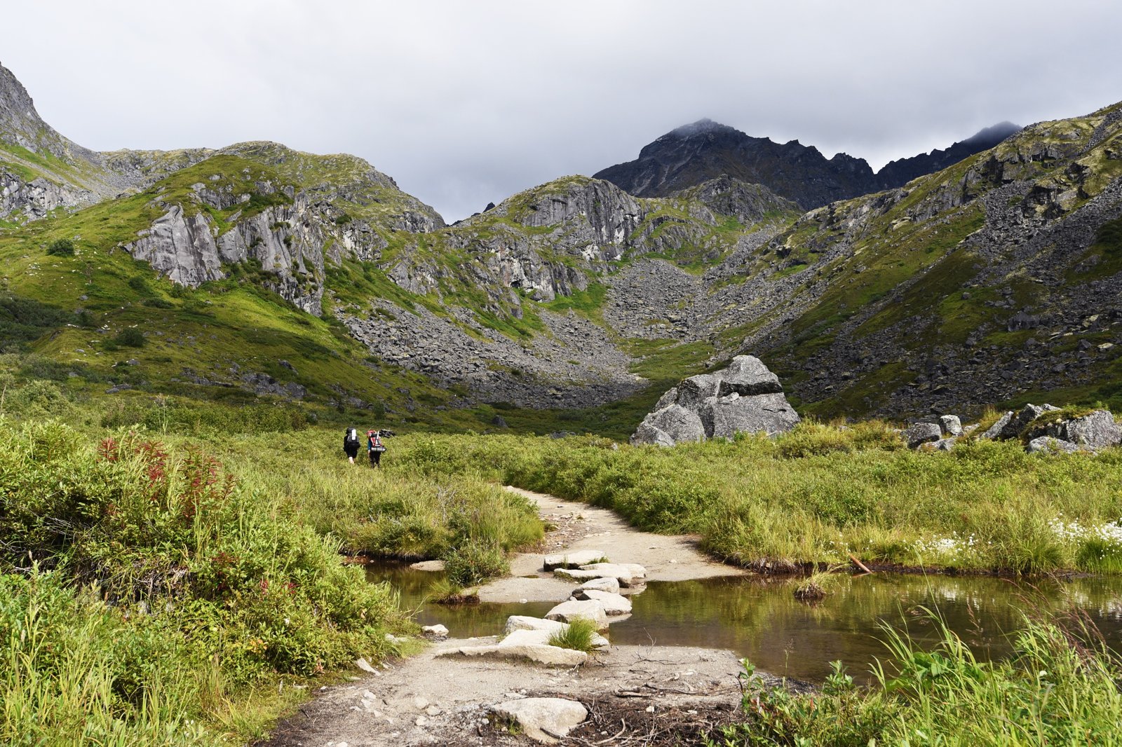
The Reed Lakes Trail climbs out of an old mining valley in Hatcher Pass to two alpine lakes below the granite peaks of the Talkeetna Mountains. Alaska State Parks calls it a popular day hike, but guides agree it makes a great overnight. You can camp at either lake, and the upper lake sits just over 4,000 feet, above timberline.
The one real obstacle is a big boulder field partway up, which is slow going with an overnight pack.
The hike
The trailhead is at mile 2.5 of Archangel Road, reached from the Palmer-Fishhook Road. Alaska State Parks lists the trail at 4.3 miles one way with about 2,000 feet of gain and rates it moderate. It allows bikes for the first 1.5 miles and hiking only beyond. One guide puts the trailhead about 1.5 hours from Anchorage and about 45 minutes from Palmer and Wasilla; another says about an hour from Anchorage and 30 minutes from downtown Palmer.
The state’s trail guide describes the route. It first follows an old roadbed through mining remains, which it asks visitors not to disturb, then climbs moderately steep slopes to a boulder field. A trail emerges from the boulders into alpine terrain, passing streams and small ponds before reaching Lower Reed Lake. From there, the trail continues past a waterfall and ends at Upper Reed Lake. Most of the route is above timberline.
The Outbound writer says the first two miles are flat, with a wide trail through a valley surrounded by granite peaks. Then the elevation comes quickly over the next 2.5 miles, climbing switchbacks with views back down the valley. Adventures of A+K says the climb picks up around mile 2, passing a waterfall on the switchbacks before the trail turns rocky.
The boulder field is the part everyone mentions. Adventures of A+K describes a stretch where the dirt trail becomes a boulder field lining a clear creek, with some huge rocks that may be hard for dogs. Lita of the Pack advises following the more worn rocks to stay on route. The Outbound writer, who did the trip as an overnight, found it challenging with a full pack. Andrea Kuuipo Abroad rates the whole hike moderate largely because of the scramble.
Past the boulders, Lower Reed Lake comes into view. Adventures of A+K says it’s about half a mile of climbing from the boulder area. The trail then passes right by a couple of smaller waterfalls on the way to Upper Reed Lake. Adventures of A+K recommends turning around on this climb for a view back down to Lower Reed Lake.
Some hikers continue beyond the lakes to the Bomber Glacier, which AllTrails calls historic. Reviewers who went describe a long, steep boulder field to the pass, recommend crampons, call it a tough hike, and suggest camping at one of the lakes first. This page covers only the Reed Lakes.
The season is short. 90summers says Archangel Road is typically closed from mid-September to July 1, which adds miles if you park at the gate.
For another overnight near Anchorage, see Williwaw Lakes.
Tips
- Check the road. 90summers says Archangel Road is usually closed from September 15 to July 1. If it’s closed, the hike gets about 5 miles longer round trip.
- Take the boulders slowly. Several guides say the boulder field is the hardest part, especially with a full pack.
- Watch your dog. Adventures of A+K says the big boulders can be hard on dogs.
- Carry bear spray and a bear canister. Andrea Kuuipo Abroad and Adventures of Nicole both recommend a bear vault for food.
- Drive Archangel Road carefully. Adventures of Nicole warns it can be rough near the bridge before the trailhead.
Camping
Camping is allowed near both lakes. 90summers says to camp at least 200 feet from any water. Guides disagree on whether there are designated sites. A 2026 guide says there are a couple of signed tent areas and asks campers to use only those. An older guide says there are no designated sites and suggests using already-flattened spots. Check with Alaska State Parks before you go, and pack out everything.
Inside Intel: Lower Reed Lake is the camper favorite. Adventures of Nicole says it has much better spots than Upper Reed Lake, and the Outbound writer, who camped overnight, found plenty of places to pitch a tent there. If you’d rather sleep by the upper lake, Andrea Kuuipo Abroad points to the south shoreline or a couple of small hills southeast of the shore, about 200 to 400 feet away.
Trail facts
- Distance: About 8.6 miles round trip to Upper Reed Lake (4.3 miles each way)
- Route type: Out and back
- Difficulty: Moderate (Alaska State Parks). Boulder field scramble.
- Elevation: About 2,000 feet of gain (Alaska State Parks). Upper Reed Lake just over 4,000 feet.
- Campsites: Near Lower and Upper Reed Lakes
- Water: Streams and lakes. Treat all water.
- Permits: None found
- Trail use: Bikes allowed for the first 1.5 miles; hiking only beyond
- Trailhead: Mile 2.5 Archangel Road, off Palmer-Fishhook Road, Hatcher Pass
- Season: Roughly July to mid-September when Archangel Road is open
- Last verified: September 28, 2026
Where this comes from
This page draws on the sources below, along with other guides and trip reports. Links go to the original pages.
- Alaska State Parks: Guide to Reed Lakes Trail and Gold Mint Trail (PDF)
- Andrea Kuuipo Abroad: Hike Reed Lakes Trail in Hatcher Pass
- Adventures of Nicole: Reed Lakes Hike
- Adventures of A+K: Reed Lakes Trail guide
- Lita of the Pack: Reed Lakes Trail
- 90summers: Reed Lakes Trail
- Outbound: Reed Lakes Trail
- AllTrails: Bomber Glacier and Reed Lakes
Before you go: This page is based on published trail guides, trip reports, and reviews, along with official park and agency information where we could find it. It’s meant to help backpackers discover new trails, not to replace current, official information. Conditions, closures, permits, campsites, and water sources change, and some details here may be out of date or wrong. Confirm everything with the managing agency and check current conditions before you head out, and don’t rely on this page alone for safety or navigation. Backcountry travel involves risk.