
Trails / Alaska / Denali State Park
K'esugi Ridge Trail
Denali State Park, Alaska State Parks (Parks Highway, north of Talkeetna)
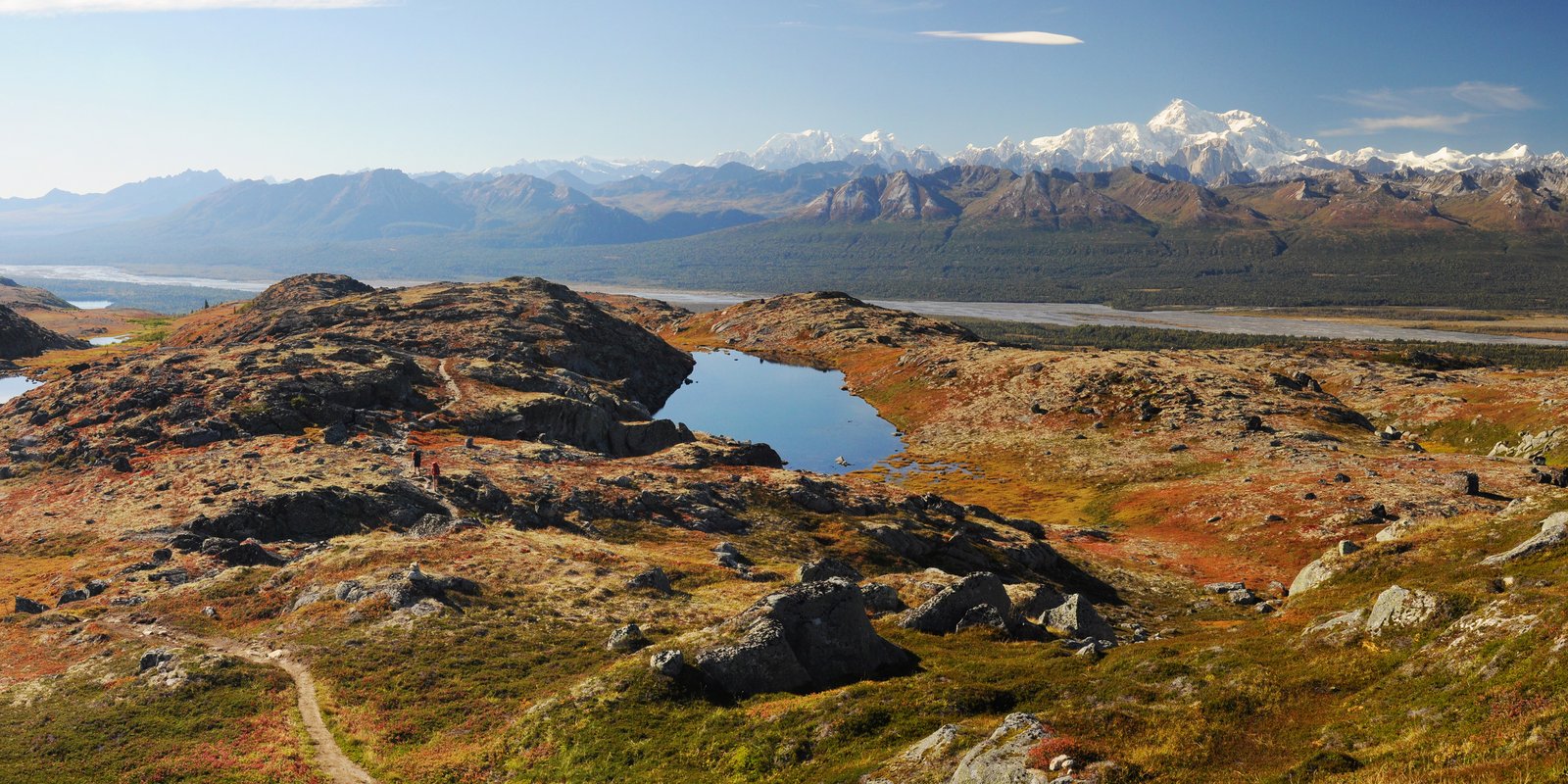
K’esugi Ridge is a long alpine ridge in Denali State Park, running parallel to the Parks Highway about an hour north of Talkeetna. On a clear day, Travel Alaska says, the view of the Denali massif from the ridge is stunning. The traverse from Little Coal Creek to Byers Lake covers about 27 to 29 miles, mostly above treeline.
Travel Alaska says K’esugi is a Dena’ina Athabascan word meaning “the Ancient One.”
The hike
Travel Alaska describes K’esugi as a ridge four to six miles wide that reaches only about 4,500 feet, without the jagged spires and knife-edge ridgelines of the Alaska Range to the west. It says the K’esugi Ridge Trail system runs 37 miles along the alpine ridgeline, with access at the Little Coal Creek, Ermine Hill, Byers Lake, and Upper Troublesome Creek trailheads.
Alaska State Parks says most people hike north to south because there’s less total elevation gain. The usual start is the Little Coal Creek Trailhead at mile 163.9 of the Parks Highway. The state’s brochure says the Little Coal Creek Trail climbs alongside the creek to the northern end of the ridge and is the easiest way up. Its north guide lists that climb at 3.3 miles and about 1,750 feet. One AllTrails reviewer called the first three or four miles a moderately difficult climb.
Once on top, the trail follows the ridge south across rolling tundra. The Alaska State Parks north guide lists the 10.8 miles from the top of Little Coal Creek to the Ermine Hill junction. It gives a 17.8-mile traverse from Little Coal Creek to the Ermine Hill Trailhead and 28.9 miles to Byers Lake. Ermine Hill, the brochure says, winds through woods and over Giardia Creek before switchbacking up to the ridge, and can serve as an exit.
South of Ermine Hill, conditions change. One AllTrails reviewer found the ridge smooth going until about mile 14, then called the stretch from Ermine Hill to Skinny Lake a miserable slog, muddy and overgrown. The same reviewer called Skinny Lake to the Byers Lake overlook very easy and the most beautiful part of the trail.
The trail finishes by descending to Byers Lake on the Cascade Trail. The Denali Guidebook says the Byers Lake trail up the ridge is steep, and slippery when dry and worse when wet. Travel Alaska says Byers Lake Campground, at mile 147, has 73 campsites, six walk-in sites at Byers Lake Lakeshore Campground, and three public-use cabins.
The trail system continues south. ALASKA.ORG notes 11.7 more miles from the final junction to the Upper Troublesome Creek Trailhead, mostly through a forested valley. It also says Upper Troublesome Creek is often closed because of flooding and bear activity, so check with Alaska’s Department of Natural Resources first.
Alaska State Parks warns that weather on K’esugi Ridge can change fast. Wikipedia lists bears and severe weather as the trail’s hazards. The same park guides note that some trails may close seasonally when bear concentrations are high.
For another multi-day Alaska route, see the Resurrection Pass Trail.
Tips
- Hike north to south. Alaska State Parks says this direction has less total elevation gain.
- Arrange a shuttle. The trailheads are spread along the Parks Highway; one guide puts the road distance between Little Coal Creek and Byers Lake at about 17 miles.
- Carry a stove. Sources agree open fires aren’t allowed on the ridge.
- Plan for mud. Reviewers describe the stretch between Ermine Hill and Skinny Lake as very muddy and overgrown.
- Check closures. Some trails may close because of high bear activity or flooding.
- Watch the weather. Conditions on the ridge can change fast, and much of the route is exposed.
Camping
The Denali Guidebook says backcountry camping is allowed anywhere along the ridge trail, with a designated camping area near popular Skinny Lake to reduce impact. Alaska State Parks says open fires are prohibited, so use a camp stove. Its brochure also says bear-resistant food containers may be required. Confirm the current rule with Alaska State Parks before you go. Pets must be leashed at trailheads.
Inside Intel: Skinny Lake comes up in more than one account. The Denali Guidebook points to the designated camping area there, and one AllTrails reviewer called the section from Skinny Lake to the Byers Lake overlook the most beautiful part of the traverse. The same reviewer warns that the stretch between Ermine Hill and Skinny Lake is muddy and overgrown, so allow extra time to reach it.
Trail facts
- Distance: About 27.4 to 28.9 miles, Little Coal Creek to Byers Lake. The full trail system is 37 miles.
- Route type: Point to point with a shuttle
- Difficulty: Strenuous. Steep climbs on and off the ridge; exposed, changeable weather.
- Elevation: Ridge reaches about 4,500 feet (Travel Alaska). Little Coal Creek climb about 1,750 feet in 3.3 miles.
- Campsites: Dispersed along the ridge; designated area near Skinny Lake. Byers Lake Campground and cabins at the south end.
- Water: Lakes and creeks on the ridge. Treat all water.
- Permits: None found for backcountry camping
- Fires: Prohibited on the ridge. Bring a stove.
- Bear and food storage: Bear-resistant containers may be required; confirm.
- Trailheads: Little Coal Creek (Parks Highway mile 163.9); Byers Lake Campground (mile 147); Ermine Hill and Upper Troublesome Creek are alternates.
- Season: June through September (AllTrails)
- Last verified: September 28, 2026
Where this comes from
This page draws on the sources below, along with other guides and trip reports. Links go to the original pages.
- Alaska State Parks: Denali State Park brochure (PDF)
- Alaska State Parks: Guide to K’esugi Ridge Trail System North (PDF)
- Travel Alaska: Denali State Park
- Denali Guidebook: Denali State Park Hiking
- ALASKA.ORG: Kesugi Ridge Trail Backpack
- Wikipedia: Kesugi Ridge Trail
- AllTrails: Kesugi Ridge (Curry Ridge) Trail
Before you go: This page is based on published trail guides, trip reports, and reviews, along with official park and agency information where we could find it. It’s meant to help backpackers discover new trails, not to replace current, official information. Conditions, closures, permits, campsites, and water sources change, and some details here may be out of date or wrong. Confirm everything with the managing agency and check current conditions before you head out, and don’t rely on this page alone for safety or navigation. Backcountry travel involves risk.